IMAGES TAKEN NEAR TO
Kingswood, BEWDLEY, DY12 3HR
Introduction
This page details the photographs taken nearby to Kingswood, DY12 3HR by members of the Geograph project.
The Geograph project started in 2005 with the aim of publishing, organising and preserving representative images for every square kilometre of Great Britain, Ireland and the Isle of Man.

There are currently over 7.5m images from over14,400 individuals and you can help contribute to the project by visiting https://www.geograph.org.uk
Image Map
Images are licensed for reuse under creativecommons.org/licenses/by-sa/2.0
Notes
- Clicking on the map will re-center to the selected point.
- The higher the marker number, the further away the image location is from the centre of the postcode.
Image Listing (7 Images Found)
Images are licensed for reuse under creativecommons.org/licenses/by-sa/2.0
Image
Details
Distance
1
Lower Kingswood Farm
Lower Kingswood Farm viewed from a passing footpath
Image: © Philip Halling
Taken: 20 Jul 2019
0.02 miles
2
Track to Lower Kingswood
Track and footpath to Lower Kingswood.
Image: © Philip Halling
Taken: 20 Jul 2019
0.08 miles
3
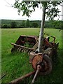
A tree growing through an old baler
Farmers seem to have the habit of abandoning old machinery and equipment around the farm and forget about it. Here an old Mccormick International baler has been here so long that a tree has grown up through it.
Image: © Philip Halling
Taken: 20 Jul 2019
0.10 miles
4
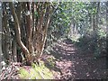
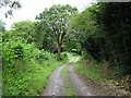
Path, Kingswood
An old, slightly sunken route.
Image: © Richard Webb
Taken: 3 Apr 2013
0.18 miles
5
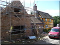
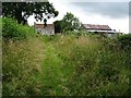
Cottage renovation near Kingswood in the Wyre Forest
I last came by this way five years ago and this place was under renovation then.
Image: © Jeremy Bolwell
Taken: 21 Aug 2011
0.20 miles
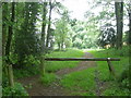
6
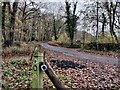
The Geopark Way at Kingswood, Wyre Forest
Wyre Forest covers an area of 26.34 square kilometres (10.17 sq mi), it straddles the borders of Worcestershire and Shropshire.
Image: © Mat Fascione
Taken: 27 Nov 2022
0.21 miles