IMAGES TAKEN NEAR TO
Kinlet, BEWDLEY, DY12 3BA
Introduction
This page details the photographs taken nearby to DY12 3BA by members of the Geograph project.
The Geograph project started in 2005 with the aim of publishing, organising and preserving representative images for every square kilometre of Great Britain, Ireland and the Isle of Man.

There are currently over 7.5m images from over14,400 individuals and you can help contribute to the project by visiting https://www.geograph.org.uk
Image Map
Images are licensed for reuse under creativecommons.org/licenses/by-sa/2.0
Notes
- Clicking on the map will re-center to the selected point.
- The higher the marker number, the further away the image location is from the centre of the postcode.
Image Listing (5 Images Found)
Images are licensed for reuse under creativecommons.org/licenses/by-sa/2.0
Image
Details
Distance
2
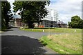
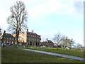
Kinlet Hall under scaffolding
For many years Kinlet Hall had been Moffats School until it closed and the hall was sold in 2020. The hall is now under scaffolding and undergoing refurbishment. In medieval times the manor of Kinlet was held by the Brampton and Cornwall families. In later years the hall which was built in 1727–29 and designed by Francis Smith of Warwick became the home of the Childe family. The house is Grade I listed, see: https://historicengland.org.uk/listing/the-list/list-entry/1053832?section=official-list-entry
Image: © Philip Halling
Taken: 5 Aug 2022
0.21 miles
3
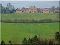
Kinlet Hall
The Grade I listed Georgian house is home to Moffats, an independent school which takes children from age 4 to 13+.
Image: © Jonathan Billinger
Taken: 3 Dec 2007
0.22 miles