IMAGES TAKEN NEAR TO
Heightington, BEWDLEY, DY12 2YS
Introduction
This page details the photographs taken nearby to DY12 2YS by members of the Geograph project.
The Geograph project started in 2005 with the aim of publishing, organising and preserving representative images for every square kilometre of Great Britain, Ireland and the Isle of Man.

There are currently over 7.5m images from over14,400 individuals and you can help contribute to the project by visiting https://www.geograph.org.uk
Image Map (Loading...)


Getting Data...Please wait
Leaflet Map data © OpenStreetMap
Images are licensed for reuse under creativecommons.org/licenses/by-sa/2.0
Notes
- Clicking on the map will re-center to the selected point.
- The higher the marker number, the further away the image location is from the centre of the postcode.
Image Listing (25 Images Found)
Images are licensed for reuse under creativecommons.org/licenses/by-sa/2.0
Image
Details
Distance
1
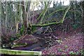
The Gladder Brook, near Ribbesford, Worcs
Apparently Gladder is the Anglo-Saxon word for "clear". Photographed from the footbridge by the Heightington Road ford.
Image: © P L Chadwick
Taken: 2 Jan 2012
0.13 miles
2
The Gladder Brook, near Ribbesford, Worcs
Another view of the Gladder Brook by the footbridge at the Heightington Road ford.
Image: © P L Chadwick
Taken: 2 Jan 2012
0.14 miles

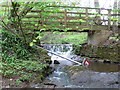
4
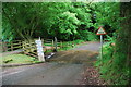
Footbridge over the Gladder Brook, near Ribbesford, Worcs
The footbridge is also used by cyclists. Photographed from the ford on Heightington Road. See:- Image
Image: © P L Chadwick
Taken: 2 Jan 2012
0.14 miles
5
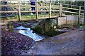
The Gladder Brook ford on Heightington Road, near Ribbesford
It is interesting to see that the brook can rise to a level where this road would become impassable. However in dry summers it can be completely dry here. On the left is a footbridge for pedestrians.
Image: © P L Chadwick
Taken: 2 Jan 2012
0.14 miles
6
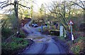
The Gladder Brook ford on Heightington Road, near Ribbesford
The water was very shallow on this day in early January. On the right is a bridge for pedestrians.
Image: © P L Chadwick
Taken: 2 Jan 2012
0.14 miles
7
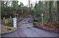
Ribbesford Ford
This ford on the Gladder Brook is found next to the entrance to Brookside Farm just off Heightington Road.
Image: © John Walton
Taken: 8 Jun 2014
0.14 miles
8
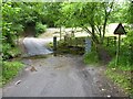
Gladder Brook Ford
Gladder Brook Ford on Heightington Road, surprisingly it is not marked on the 25,000 OS map; it is situated in the bottom of a valley with a steep 15% road descending and ascending the valley.
Image: © Philip Halling
Taken: 3 Jun 2017
0.14 miles
9
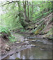
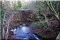
Gladder Brook
On the edge of Ribbesford Woods. From here the Gladder Brook flows southeast, through Ribbesford Woods and Areley Wood, into the River Severn.
Image: © Mat Fascione
Taken: 16 May 2012
0.15 miles
10
Footbridge across the Gladder Brook ford
Image: © Mat Fascione
Taken: 16 May 2012
0.15 miles