IMAGES TAKEN NEAR TO
Heightington, BEWDLEY, DY12 2XJ
Introduction
This page details the photographs taken nearby to DY12 2XJ by members of the Geograph project.
The Geograph project started in 2005 with the aim of publishing, organising and preserving representative images for every square kilometre of Great Britain, Ireland and the Isle of Man.

There are currently over 7.5m images from over14,400 individuals and you can help contribute to the project by visiting https://www.geograph.org.uk
Image Map (7 Images)


Getting Data...Please wait
Leaflet Map data © OpenStreetMap
Images are licensed for reuse under creativecommons.org/licenses/by-sa/2.0
Notes
- Clicking on the map will re-center to the selected point.
- The higher the marker number, the further away the image location is from the centre of the postcode.
Image Listing (7 Images Found)
Images are licensed for reuse under creativecommons.org/licenses/by-sa/2.0
Image
Details
Distance
1
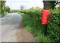
Postbox along Heightington Road
At the entrance to Farman's Court Farm.
Image: © Mat Fascione
Taken: 16 May 2012
0.05 miles
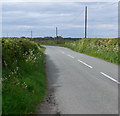
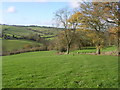
2

Farmland, Heightington
View over the Dick Brook.
Image: © Richard Webb
Taken: 23 Apr 2025
0.11 miles
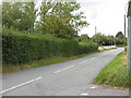
6
Worcestershire Way
Yet another steep valley on the Worcestershire Way.Greenhouse Farm left centre.
Image: © Richard Greenwood
Taken: 26 Nov 2006
0.19 miles
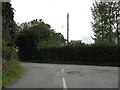
7
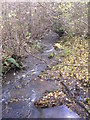
Brook
Taken from the footbridge at 756711
Image: © Richard Greenwood
Taken: 26 Nov 2006
0.22 miles