IMAGES TAKEN NEAR TO
St. Johns Lane, BEWDLEY, DY12 2QZ
Introduction
This page details the photographs taken nearby to St. Johns Lane, DY12 2QZ by members of the Geograph project.
The Geograph project started in 2005 with the aim of publishing, organising and preserving representative images for every square kilometre of Great Britain, Ireland and the Isle of Man.

There are currently over 7.5m images from over14,400 individuals and you can help contribute to the project by visiting https://www.geograph.org.uk
Image Map (Loading...)


Getting Data...Please wait
Leaflet Map data © OpenStreetMap
Images are licensed for reuse under creativecommons.org/licenses/by-sa/2.0
Notes
- Clicking on the map will re-center to the selected point.
- The higher the marker number, the further away the image location is from the centre of the postcode.
Image Listing (7 Images Found)
Images are licensed for reuse under creativecommons.org/licenses/by-sa/2.0
Image
Details
Distance
1
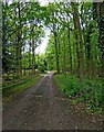
St. John's Lane, looking south
View from the end of St. John's Lane. This is a long narrow road, with many pot holes, which turns off Long Bank (the A456 Bewdley to Leominster road). It gives access to a few houses. There is a public right of way, on foot, along the whole length of the road.
Image: © P L Chadwick
Taken: 18 May 2009
0.07 miles
2
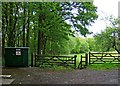
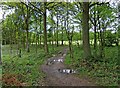
Public footpath into Wyre Forest from end of St. John's Lane
The public right of way along St. John's Lane continues onto the footpath behind the gate, and leads into the Wyre Forest. There is a sign on one of the gate posts indicating that mountain bikes are not allowed here. The green cabinet on the left has a sign indicating it is a Severn Trent Water sewage pumping station. Presumably this is for sewage from the handful of houses in St. John's Lane. Image
Image: © P L Chadwick
Taken: 18 May 2009
0.10 miles
3
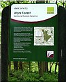
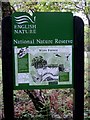
Wyre Forest National Nature Reserve information board
This information board is placed immediately at the start of the footpath, which leads from the end of St. John's Lane into the forest. It gives background information about the forest, and a map. Image
The board was put up by Natural England, which is the current quango set up to do this sort of thing (a successor to part of the Countryside Agency and other bodies). No doubt in 10 years time it will be something else.
Image: © P L Chadwick
Taken: 18 May 2009
0.11 miles
4
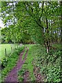
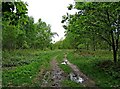
Public footpath from the Wyre Forest to St. John's Lane
This path leads out of the forest into St. John's Lane.
Image: © P L Chadwick
Taken: 18 May 2009
0.13 miles
5
Footpath in Wyre Forest
This part of the forest isn't open access land, nor is this particular path designated as a public right of way. Nevertheless it is used at times by the public, but generally speaking this area of the forest is one of the less visited parts.
Image: © P L Chadwick
Taken: 18 May 2009
0.19 miles
6
English Nature National Nature Reserve information board in Wyre Forest
This relatively little visited corner of the forest does quite well for information boards. Here is another, which explains the different kinds of flora and fauna, which can be found here. The board was put up by English Nature, who were responsible for many nature reserves. But now they have been absorbed into Natural England, so at some point a new board will undoubtedly be arriving. A new one has already been put here: Image
Image: © P L Chadwick
Taken: 18 May 2009
0.19 miles
7
Start of public footpath through Lord's Yard Coppice, Wyre Forest
There are a number of footpaths around here, but this is the only one designated as a public right of way.
Image: © P L Chadwick
Taken: 18 May 2009
0.22 miles