IMAGES TAKEN NEAR TO
Longbank, BEWDLEY, DY12 2QS
Introduction
This page details the photographs taken nearby to Longbank, DY12 2QS by members of the Geograph project.
The Geograph project started in 2005 with the aim of publishing, organising and preserving representative images for every square kilometre of Great Britain, Ireland and the Isle of Man.

There are currently over 7.5m images from over14,400 individuals and you can help contribute to the project by visiting https://www.geograph.org.uk
Image Map (Loading...)


Getting Data...Please wait
Leaflet Map data © OpenStreetMap
Images are licensed for reuse under creativecommons.org/licenses/by-sa/2.0
Notes
- Clicking on the map will re-center to the selected point.
- The higher the marker number, the further away the image location is from the centre of the postcode.
Image Listing (8 Images Found)
Images are licensed for reuse under creativecommons.org/licenses/by-sa/2.0
Image
Details
Distance
1
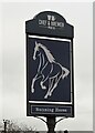
Sign for the Running Horse Chef & Brewer pub
Image: © JThomas
Taken: 17 Apr 2023
0.10 miles
5

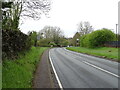
Running Horse Inn at Long Bank, Bewdley
Image: © Mat Fascione
Taken: 27 Nov 2022
0.12 miles
6
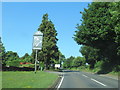
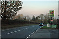
A456 at Longbank passing The Running Horse Pub
Image: © Roy Hughes
Taken: 25 Jun 2020
0.12 miles
7
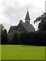
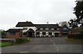
Beaucastle
This fairy tale castle was built by George Baker, a Birmingham industrialist and friend of John Ruskin. They established the Guild of St George.In August 1889 Thomas & Margaret Harley set out from Mulberry Cottage for the Wyre Forest just outside Bewdley in Worcestershire. They were the first of five families who would settle on land owned by George Baker, a wealthy member of the Guild who had bought a large estate to develop to a plan guided by Ruskin. In the oak forest the families carved out smallholdings for themselves. Some bought plots, others settled on land that Baker gifted to the Guild and a community gradually grew up on the smallholdings.
Image: © Richard Greenwood
Taken: 8 Oct 2006
0.16 miles
8
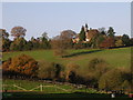
Beaucastle
Although taken from the next square, this photo clearly shows Beaucastle's dominant position from the East. The trees in the foreground mark the line of the brook flowing NE across the top of the square. For history of Beaucastle see Image
Image: © Richard Greenwood
Taken: 18 Nov 2006
0.19 miles