IMAGES TAKEN NEAR TO
Tanners Hill, BEWDLEY, DY12 2LS
Introduction
This page details the photographs taken nearby to Tanners Hill, DY12 2LS by members of the Geograph project.
The Geograph project started in 2005 with the aim of publishing, organising and preserving representative images for every square kilometre of Great Britain, Ireland and the Isle of Man.

There are currently over 7.5m images from over14,400 individuals and you can help contribute to the project by visiting https://www.geograph.org.uk
Image Map (Loading...)


Getting Data...Please wait
Leaflet Map data © OpenStreetMap
Images are licensed for reuse under creativecommons.org/licenses/by-sa/2.0
Notes
- Clicking on the map will re-center to the selected point.
- The higher the marker number, the further away the image location is from the centre of the postcode.
Image Listing (4 Images Found)
Images are licensed for reuse under creativecommons.org/licenses/by-sa/2.0
Image
Details
Distance
1
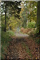
Footpath in the Wyre Forest
Footpath through the Wyre Forest near St George's Farm.
Image: © Philip Halling
Taken: 1 Nov 2008
0.04 miles
2
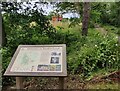
Information board at Ruskin Land
Ruskin Land is made up of a hundred acres of mostly oak woodland, two farmhouses, a sawmill and an orchard and wildflower meadow. It is managed by the Wyre Community Land Trust.
In the distance is St George's Farmhouse.
Image: © Mat Fascione
Taken: 5 Jul 2023
0.06 miles
3
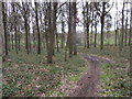
Through Shelf Held Coppice near St. George's Farm
Image: © Liz Stone
Taken: 11 May 2012
0.18 miles
4
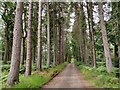
Track through Ruskin Land
Ruskin Land is made up of a hundred acres of mostly oak woodland, two farmhouses, a sawmill and an orchard and wildflower meadow. It is managed by the Wyre Community Land Trust.
Image: © Mat Fascione
Taken: 5 Jul 2023
0.19 miles