IMAGES TAKEN NEAR TO
High Clere, BEWDLEY, DY12 2EY
Introduction
This page details the photographs taken nearby to High Clere, DY12 2EY by members of the Geograph project.
The Geograph project started in 2005 with the aim of publishing, organising and preserving representative images for every square kilometre of Great Britain, Ireland and the Isle of Man.

There are currently over 7.5m images from over14,400 individuals and you can help contribute to the project by visiting https://www.geograph.org.uk
Image Map (Loading...)


Getting Data...Please wait
Leaflet Map data © OpenStreetMap
Images are licensed for reuse under creativecommons.org/licenses/by-sa/2.0
Notes
- Clicking on the map will re-center to the selected point.
- The higher the marker number, the further away the image location is from the centre of the postcode.
Image Listing (26 Images Found)
Images are licensed for reuse under creativecommons.org/licenses/by-sa/2.0
Image
Details
Distance
1
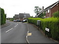
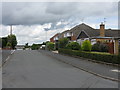
Bewdley - Highclere
Part of an extensive housing estate west of the town.
Image: © Peter Whatley
Taken: 14 Jul 2009
0.04 miles
2
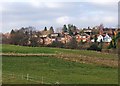
The edge of Bewdley
Where the fields meet the built up suburbs of Bewdley.
Image: © P L Chadwick
Taken: 27 Dec 2008
0.09 miles
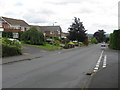
4
Bewdley - Unadopted Road Off Park Lane
An unadopted road leading west from Park Lane which eventually leads to a footpath.
Image: © Peter Whatley
Taken: 14 Jul 2009
0.14 miles
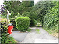
6
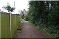
Public footpath behind Park Lane, Bewdley, Worcs
A public footpath runs along this lane, which is behind and adjacent to Park Lane.
Image: © P L Chadwick
Taken: 27 Mar 2021
0.17 miles
7
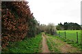
Track & public footpath, near Bewdley, Worcs
This track, over which a public footpath runs, is accessed through gates, including a kissing gate for pedestrians, from behind the camera position. Only authorised vehicles can drive over it. On the right is a recreation ground.
Image
Image
Image: © P L Chadwick
Taken: 27 Mar 2021
0.17 miles
8
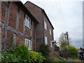
Restored houses on Sandy Bank, Bewdley
The Civic Society plaque states that these historic old buildings were restored in the early 1990's by the County of Hereford & Worcester Building Preservation Trust Ltd. Good work.
Image: © Jeremy Bolwell
Taken: 9 Nov 2012
0.17 miles
10
The Black Boy - pub sign, 50 Wyre Hill
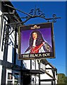
This splendid new sign has only been up a few months, and replaces the previous much-faded Banks's sign. It shows King Charles II. Bewdley was a strongly Royalist town in the 17th century civil war between the Royalists and Parliament. During the few years the country was a republic under Oliver Cromwell, the Royal Toast was forbidden. It became the custom for Royalists in that period to drink a toast to the health of "The Black Boy Across The Water". This was a reference to the fact that Charles II had a fairly dark complexion. Eventually he was restored to the English throne in 1660.
Subsequently quite a number of pubs were named the Black Boy. Bewdley was unusual in having three establishments with this name, one being the former Black Boy Hotel in the Wribbenhall district, now renamed the Bewdley Hotel. The third, long closed, had a statue or model of a black boy attached to the outside. When it closed the model was transferred to the Black Boy on Wyre Hill. It was affixed to the front of the building until eventually it fell off and broke. In the lounge bar is a fascinating old photograph showing the pub with this model.
Image
Image: © P L Chadwick
Taken: 25 Oct 2010
0.18 miles