IMAGES TAKEN NEAR TO
Trimpley, BEWDLEY, DY12 1PE
Introduction
This page details the photographs taken nearby to DY12 1PE by members of the Geograph project.
The Geograph project started in 2005 with the aim of publishing, organising and preserving representative images for every square kilometre of Great Britain, Ireland and the Isle of Man.

There are currently over 7.5m images from over14,400 individuals and you can help contribute to the project by visiting https://www.geograph.org.uk
Image Map (Loading...)


Getting Data...Please wait
Leaflet Map data © OpenStreetMap
Images are licensed for reuse under creativecommons.org/licenses/by-sa/2.0
Notes
- Clicking on the map will re-center to the selected point.
- The higher the marker number, the further away the image location is from the centre of the postcode.
Image Listing (16 Images Found)
Images are licensed for reuse under creativecommons.org/licenses/by-sa/2.0
Image
Details
Distance
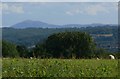
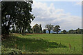
3
Worcestershire farmland near Trimpley
Looking west from near the lane to Eymore Wood and Trimpley Reservoir. The private road leads to Holbeache House.
On the skyline, Brown Clee Hill is (540 metres height, 1772 feet) just over twelve miles distant. Partly hidden by the tree, left of centre, is Titterstone Clee Hill (533 metres, 1749 feet).
Image: © Roger Kidd
Taken: 23 Aug 2021
0.19 miles
4
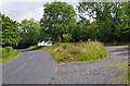
Layby and road near Trimpley
This minor road comes up from the Severn Trent water treatment plant by the River Severn, and Eymore Wood, and passes through the small village of Trimpley. On the verge between the road and the layby, some poppies have very recently appeared.
Image
Image: © P L Chadwick
Taken: 31 Jul 2011
0.19 miles
5
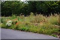
Poppies in the roadside verge near Trimpley
In the last couple of weeks, a few poppies have emerged here. It is surprising because the impressive displays, a few miles away, in fields near Bewdley, which appeared in early June, have almost completely disappeared.
Image
Image: © P L Chadwick
Taken: 31 Jul 2011
0.20 miles
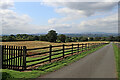
6
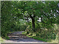
Slip road by the lane to Eymore Road, Trimpley
Looking west, this little slip road is by a bend in the lane between Trimpley village and Trimpley Reservoir.
Image: © Roger Kidd
Taken: 23 Aug 2021
0.20 miles
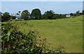
8
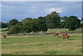
Pasture west of Trimpley in Worcestershire
Looking south-west from the lane to Trimpley Reservoir near The Guildings.
Image: © Roger Kidd
Taken: 23 Aug 2021
0.21 miles
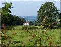
9
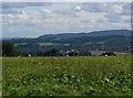
View south across Bewdley
The higher ground in the distance is Abberley Hill, about twelve kilometres away.
Image: © Mat Fascione
Taken: 28 Aug 2010
0.21 miles