IMAGES TAKEN NEAR TO
Kidderminster Road, BEWDLEY, DY12 1LN
Introduction
This page details the photographs taken nearby to Kidderminster Road, DY12 1LN by members of the Geograph project.
The Geograph project started in 2005 with the aim of publishing, organising and preserving representative images for every square kilometre of Great Britain, Ireland and the Isle of Man.

There are currently over 7.5m images from over14,400 individuals and you can help contribute to the project by visiting https://www.geograph.org.uk
Image Map (Loading...)


Getting Data...Please wait
Leaflet Map data © OpenStreetMap
Images are licensed for reuse under creativecommons.org/licenses/by-sa/2.0
Notes
- Clicking on the map will re-center to the selected point.
- The higher the marker number, the further away the image location is from the centre of the postcode.
Image Listing (15 Images Found)
Images are licensed for reuse under creativecommons.org/licenses/by-sa/2.0
Image
Details
Distance
1
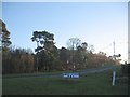
A456 Kidderminster Road near the West Midlands Safari Park
Image: © Mat Fascione
Taken: 13 Aug 2023
0.06 miles
3
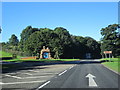
A456 Westbound Passing Entrance to Safari Park
Image: © Roy Hughes
Taken: 22 Sep 2016
0.13 miles
4
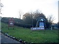
West Midlands Safari Park
The entrance from the Bewdley - Kidderminster Road in the north of the square.
Image: © David Stowell
Taken: 11 Dec 2005
0.19 miles
5
West Midlands Safari Park
Looking up the driveway from the entrance on the Kidderminster - Bewdley road, with the Christmas decorations in place.
Image: © David Stowell
Taken: 11 Dec 2005
0.19 miles
6
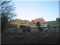
Two horses and the moon
Two of the local residents who were grazing in the NE corner of the square came to see why I was here.
Image: © David Stowell
Taken: 11 Dec 2005
0.19 miles
9
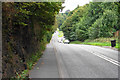
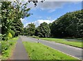
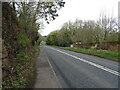
Kidderminster Road
The A456 heading towards Kidderminster. The sandstone face on the left is quite a common feature locally.
Image: © Bill Boaden
Taken: 14 Sep 2018
0.20 miles
10
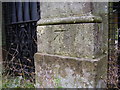
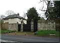
Nineteenth-century benchmark on gate pier
This bench mark was established between 1849 and 1855 during the First primary levelling of England & Wales, and was levelled with a height of 142.0630 feet [43.3008 metres] above mean sea level (Liverpool datum). It was included on the Worcester to Aberystwyth (Branch Line from Bewdley to Kidderminster) levelling line. The surveyor's description was "No. 4. Mark on pier of gate at N. entrance to Spring Grove, at S. side of road ; 1.12 ft. above surface" (Public Abstract p.558).
Image: © Shantavira
Taken: 22 Oct 2015
0.21 miles