IMAGES TAKEN NEAR TO
High Street, DUDLEY, DY1 1QD
Introduction
This page details the photographs taken nearby to High Street, DY1 1QD by members of the Geograph project.
The Geograph project started in 2005 with the aim of publishing, organising and preserving representative images for every square kilometre of Great Britain, Ireland and the Isle of Man.

There are currently over 7.5m images from over14,400 individuals and you can help contribute to the project by visiting https://www.geograph.org.uk
Image Map
Images are licensed for reuse under creativecommons.org/licenses/by-sa/2.0
Notes
- Clicking on the map will re-center to the selected point.
- The higher the marker number, the further away the image location is from the centre of the postcode.
Image Listing (516 Images Found)
Images are licensed for reuse under creativecommons.org/licenses/by-sa/2.0
Image
Details
Distance
1
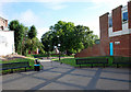
The Inhedge Gardens, Dudley
View of the footpath leading to the gardens from Upper High Street near St Thomas's Church.
Image: © Brian Clift
Taken: 25 Jul 2010
0.01 miles
2
The Inhedge Gardens, Dudley
View of the footpath leading to Upper High Street and St Thomas's Church.
Image: © Brian Clift
Taken: 25 Jul 2010
0.01 miles
3
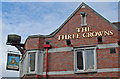
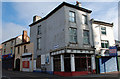
The Three Crowns, Dudley
Detail from the public house located on the corner of High Street and Stafford Street.
Image: © Brian Clift
Taken: 25 Jul 2010
0.02 miles
4
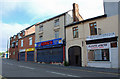
Stafford Street, Dudley
A few shops near Top Church.
Image: © Brian Clift
Taken: 25 Jul 2010
0.02 miles
5
NW corner of United Footwear premises, Dudley
The address is 80-81 High Street, but that side of the shop is only about 20 metres long, in contrast to this side, which extends for 60 metres along the whole length of the eastern side of Vicar Street.
Scaffolding surrounds the lower part of the building, perhaps in place for work to remedy the blotchy appearance of the walls.
Image: © Jaggery
Taken: 5 May 2012
0.02 miles
6
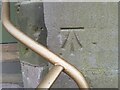
Ordnance Survey Cut Mark
This OS cut mark can be found on the north face of St Thomas's Church. It marks a point 212.540m above mean sea level.
Image: © Adrian Dust
Taken: 10 Jul 2021
0.02 miles
7
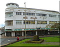
High Street, Dudley
Opposite Top Church the building that once housed one of Dudley's cinemas. Latterly the cinema was The Gaumont and prior to that it was called The Regent.
Image: © Brian Clift
Taken: 25 Jul 2010
0.02 miles
8
High Street, Dudley
Building on the corner of Stafford Street.
Image: © Brian Clift
Taken: 25 Jul 2010
0.02 miles
9
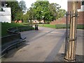
Seats at the entry to an open space between High Street and The Inhedge, Dudley
This space is opposite the parish church. Out of shot, left, is the Venue.
Image: © Robin Stott
Taken: 29 Sep 2013
0.02 miles
10
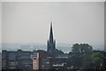
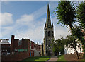
St Thomas's Church Dudley
Dudley Top Church viewed from Dudley Castle.
Image: © Brian Clift
Taken: 19 Sep 2008
0.02 miles