IMAGES TAKEN NEAR TO
Court Passage, DUDLEY, DY1 1EX
Introduction
This page details the photographs taken nearby to Court Passage, DY1 1EX by members of the Geograph project.
The Geograph project started in 2005 with the aim of publishing, organising and preserving representative images for every square kilometre of Great Britain, Ireland and the Isle of Man.

There are currently over 7.5m images from over14,400 individuals and you can help contribute to the project by visiting https://www.geograph.org.uk
Image Map
Images are licensed for reuse under creativecommons.org/licenses/by-sa/2.0
Notes
- Clicking on the map will re-center to the selected point.
- The higher the marker number, the further away the image location is from the centre of the postcode.
Image Listing (659 Images Found)
Images are licensed for reuse under creativecommons.org/licenses/by-sa/2.0
Image
Details
Distance
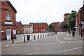
1

Stone Street, Dudley
Shops, including the building that was once The Albion public house.
Image: © Brian Clift
Taken: 25 Jul 2010
0.00 miles
2
Stone Street, Dudley
View in the direction of St James's Road.
Image: © Brian Clift
Taken: 25 Jul 2010
0.01 miles
3
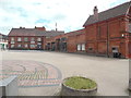
Stone Street, Dudley
View across the Old Market Square from Tower Street.
Image: © Brian Clift
Taken: 25 Jul 2010
0.01 miles
4
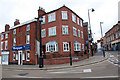
Stone Street, Dudley
At the corner of Tower Street.
Image: © Brian Clift
Taken: 25 Jul 2010
0.01 miles
6
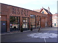
Glass House
The view of the new restaurant in Stone Street Square in Dudley.
Image: © Gordon Griffiths
Taken: 11 Oct 2015
0.01 miles
7
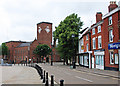
Former Trolleybus Terminus in Dudley
Taken from Priory Street, this photo shows the former terminus in Stone Street for the trolleybus route 58 which ran from Wolverhampton to Dudley via Sedgley until its final day of operation on Sunday 5th March 1967. The current route 1 now runs to the bus station in Dudley, then goes along Priory Street after which it follows the ex trolleybus route to Wolverhampton. The same route then goes on to Tettenhall Wood via the former trolleybus route 1 which ran from Wolverhampton to Tettenhall until that closed on Sunday 30th June 1963. It is to be hoped that electric buses may sometime in the future make a comeback on the present route 1, but without the overhead wiring. The heavy-duty bus shelters have since been taken out and replaced by The Old Glass House Restaurant, their being a glasshouse in this market place until 1886. It was demolished and replaced by fish and vegetable markets. The old Fire Station can be seen to the right of the photo.
Image: © David Hillas
Taken: 2 Jun 2018
0.01 miles
8
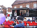
Black Country Day Festival
The view of the Dudley Festival in Stone Square, Dudley. The Black Country Day is July 14.
Image: © Gordon Griffiths
Taken: 15 Jul 2017
0.02 miles
9
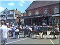
Black Country Day 2018
The view of the stage in Stone Street Square in Dudley.
Image: © Gordon Griffiths
Taken: 14 Jul 2018
0.02 miles
10

Stone Street, Dudley
View across the Old Market Square towards Tower Street from the corner of Priory Street.
Image: © Brian Clift
Taken: 25 Jul 2010
0.02 miles