IMAGES TAKEN NEAR TO
Dowles Road, KIDDERMINSTER, DY11 7FR
Introduction
This page details the photographs taken nearby to Dowles Road, DY11 7FR by members of the Geograph project.
The Geograph project started in 2005 with the aim of publishing, organising and preserving representative images for every square kilometre of Great Britain, Ireland and the Isle of Man.

There are currently over 7.5m images from over14,400 individuals and you can help contribute to the project by visiting https://www.geograph.org.uk
Image Map (Loading...)


Getting Data...Please wait
Leaflet Map data © OpenStreetMap
Images are licensed for reuse under creativecommons.org/licenses/by-sa/2.0
Notes
- Clicking on the map will re-center to the selected point.
- The higher the marker number, the further away the image location is from the centre of the postcode.
Image Listing (23 Images Found)
Images are licensed for reuse under creativecommons.org/licenses/by-sa/2.0
Image
Details
Distance
1
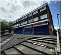
Closed shops on Severn Grove, Kidderminster
Image: © Mat Fascione
Taken: 21 Jun 2023
0.11 miles
2
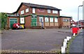
The Musketeer, Avon Road, Kidderminster
This is the estate pub for the Rifle Range Estate. The pub also has an off-licence.
Image: © P L Chadwick
Taken: 11 Jan 2009
0.11 miles
3
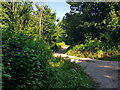
Path through the Rifle Range Nature Reserve
Image: © Mat Fascione
Taken: 4 Jan 2023
0.13 miles
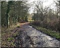
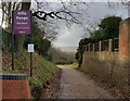
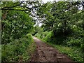
4
Tarmac track to the Rifle Range Nature Reserve
Image: © Mat Fascione
Taken: 21 Jun 2023
0.15 miles
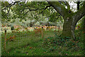
5
Tracks in Gorse Covert
Near Rifle Range Nature Reserve.
Image: © Jeff Gogarty
Taken: 23 Jun 2022
0.15 miles
6
Entrance to the Rifle Range Nature Reserve
At the end of Rifle Range Road.
Image: © Mat Fascione
Taken: 4 Jan 2023
0.16 miles
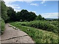
7
Heathland in the Rifle Range Nature Reserve, Worcestershire
This is in Gorse Covert on the eastern side of the nature reserve. There are many tracks and footpaths on the two nature reserves here. As the site has developed, some historic public footpaths now appear vary from the positions and courses shown on maps, yet they are still there.
Image: © Roger Kidd
Taken: 15 Oct 2020
0.17 miles
9
Track through Gorse Covert
Part of the Rifle Range Nature Reserve, on the western edge of Kidderminster.
Image: © Mat Fascione
Taken: 21 Jun 2023
0.18 miles
10
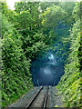
Bewdley Tunnel in Worcestershire
This is on the Severn Valley Railway, looking south-west towards Bewdley Station and Bridgnorth. The tunnel is 480 yards (439 metres) long. It was built in 1876-1887 on the Kidderminster Loop Line.
https://www.svrwiki.com/Bewdley_Tunnel https://www.reelstreets.com/films/signalman-the/
Image: © Roger Kidd
Taken: 14 May 2014
0.18 miles