IMAGES TAKEN NEAR TO
Tolley Road, KIDDERMINSTER, DY11 7EW
Introduction
This page details the photographs taken nearby to Tolley Road, DY11 7EW by members of the Geograph project.
The Geograph project started in 2005 with the aim of publishing, organising and preserving representative images for every square kilometre of Great Britain, Ireland and the Isle of Man.

There are currently over 7.5m images from over14,400 individuals and you can help contribute to the project by visiting https://www.geograph.org.uk
Image Map (Loading...)


Getting Data...Please wait
Leaflet Map data © OpenStreetMap
Images are licensed for reuse under creativecommons.org/licenses/by-sa/2.0
Notes
- Clicking on the map will re-center to the selected point.
- The higher the marker number, the further away the image location is from the centre of the postcode.
Image Listing (12 Images Found)
Images are licensed for reuse under creativecommons.org/licenses/by-sa/2.0
Image
Details
Distance
1
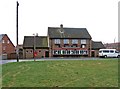
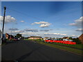
The Radcliffe Arms, Meredith Green, Kidderminster
This is the local public house for the large Birchen Coppice council built housing estate in the south west of Kidderminster. Building of the estate commenced in 1946, so the public house was probably built around the 1950's. It faces onto a large green, part of which can be seen here.
Image: © P L Chadwick
Taken: 11 Jan 2009
0.02 miles
2
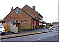
The Radcliffe Arms (side view), Meredith Green, Kidderminster
Estate pub on the Birchen Coppice housing estate. Another view Image
Image: © P L Chadwick
Taken: 11 Jan 2009
0.02 miles
4
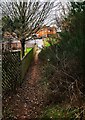
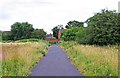
Footpath connecting Vicarage Farm Heath & Whittall Drive West, Kidderminster, Worcs
This footpath, running from Whittall Drive East, connects the nearby part of the Birchen Coppice Estate with Victoria Farm Heath Nature Reserve.
Image
Image: © P L Chadwick
Taken: 6 Mar 2021
0.16 miles
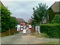
5
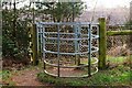
Kissing gate at entrance to Victoria Farm Heath, Kidderminster, Worcs
This kissing gate is at the end of a footpath from Whittall Drive West, and connects the nearby part of the Birchen Coppice Estate with the Victoria Farm Heath nature reserve. There are several other entrances to the reserve, both from the estate and elsewhere.
Image
Image: © P L Chadwick
Taken: 6 Mar 2021
0.18 miles
6
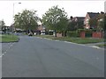
Walter Nash Road East
The view along the road in Kidderminster, Worcs.
Image: © Gordon Griffiths
Taken: 13 Sep 2023
0.19 miles
8
Footpath at Burlish Top approaching Gould Avenue West, Kidderminster
Gould Avenue West is on the large Birchen Coppice Estate.
Image
Image: © P L Chadwick
Taken: 28 Jul 2012
0.21 miles
9
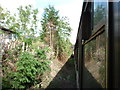
Heading towards Kidderminster
Taken from the Severn Valley Railway.
Image: © Ian S
Taken: 17 Sep 2011
0.22 miles
10
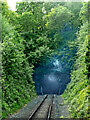
Bewdley Tunnel in Worcestershire
This is on the Severn Valley Railway, looking south-west towards Bewdley Station and Bridgnorth. The tunnel is 480 yards (439 metres) long. It was built in 1876-1887 on the Kidderminster Loop Line.
https://www.svrwiki.com/Bewdley_Tunnel https://www.reelstreets.com/films/signalman-the/
Image: © Roger Kidd
Taken: 14 May 2014
0.23 miles