IMAGES TAKEN NEAR TO
Kirkby Drive, KIDDERMINSTER, DY11 7DW
Introduction
This page details the photographs taken nearby to Kirkby Drive, DY11 7DW by members of the Geograph project.
The Geograph project started in 2005 with the aim of publishing, organising and preserving representative images for every square kilometre of Great Britain, Ireland and the Isle of Man.

There are currently over 7.5m images from over14,400 individuals and you can help contribute to the project by visiting https://www.geograph.org.uk
Image Map
Images are licensed for reuse under creativecommons.org/licenses/by-sa/2.0
Notes
- Clicking on the map will re-center to the selected point.
- The higher the marker number, the further away the image location is from the centre of the postcode.
Image Listing (153 Images Found)
Images are licensed for reuse under creativecommons.org/licenses/by-sa/2.0
Image
Details
Distance
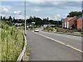
2
Roundabout on Silverwoods Way, Kidderminster, Worcs
Silverwoods Way is the main road serving the new developments on the former British Sugar Corporation site. At present it is the only road actually connected to the roundabout, but in time that will change.
Image
Image
Image: © P L Chadwick
Taken: 16 Apr 2017
0.07 miles
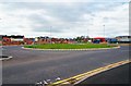
3
Roundabout on Silverwoods Way, Kidderminster, Worcs
Silverwoods Way is the main road serving the new developments on the former British Sugar Corporation site. At present it is the only road actually connected to the roundabout, but in time that will change.
Image
Image
Image: © P L Chadwick
Taken: 16 Apr 2017
0.07 miles
4
New houses along Silverwoods Way, Kidderminster
The houses have been built on the site of the former British Sugar factory, which closed in 2004.
Image: © Mat Fascione
Taken: 30 Jun 2020
0.08 miles
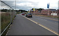
5
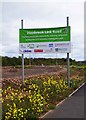
Hoobrook Link Road sign, Silverwoods Way, Kidderminster, Worcs
The Hoobrook Link Road crosses the former British Sugar Corporationn site, which is now being redeveloped for residential and other uses. The road links the A451 and A442 roads. It has now been named Silverwoods Way. This sign reads:- "Hoobrook Link Road. Improving access and connectivity, reducing congestion, growing the local economy, creating more jobs."
Image: © P L Chadwick
Taken: 16 Apr 2017
0.08 miles
6
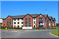
Foley Grange
Care home in Kidderminster.
Image: © Wayland Smith
Taken: 27 May 2023
0.10 miles
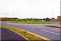
7

Future road off roundabout, Silverwoods Way, Kidderminster, Worcs
A future road will lead off here once this part of the former British Sugar Corporation site is under redevelopment.
Image
Image
Image: © P L Chadwick
Taken: 16 Apr 2017
0.10 miles
8
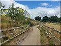
Path to the Staffordshire and Worcestershire Canal
Image: © Mat Fascione
Taken: 25 Jul 2022
0.11 miles
9
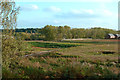
The Site of Kidderminster Sugar Factory
The old railway sidings have gone and the area is being developed for light industry, housing and leisure facilities.
Image: © Mary and Angus Hogg
Taken: 15 Oct 2017
0.11 miles
10

Canal approaching Kidderminster in Worcestershire
Looking north towards Kidderminster centre.
Ahead is a new bridge, No 10A which carries the A4420 Silverwoods Way. This is a road linking the A451 Stourport Road with the A442 and A449 Worcester roads. Extensive redevelopment of the former British Sugar Corporation site has made this bridge a necessity.
Image: © Roger D Kidd
Taken: 23 Aug 2017
0.11 miles