IMAGES TAKEN NEAR TO
Larches Road, KIDDERMINSTER, DY11 7AB
Introduction
This page details the photographs taken nearby to Larches Road, DY11 7AB by members of the Geograph project.
The Geograph project started in 2005 with the aim of publishing, organising and preserving representative images for every square kilometre of Great Britain, Ireland and the Isle of Man.

There are currently over 7.5m images from over14,400 individuals and you can help contribute to the project by visiting https://www.geograph.org.uk
Image Map (Loading...)


Getting Data...Please wait
Leaflet Map data © OpenStreetMap
Images are licensed for reuse under creativecommons.org/licenses/by-sa/2.0
Notes
- Clicking on the map will re-center to the selected point.
- The higher the marker number, the further away the image location is from the centre of the postcode.
Image Listing (154 Images Found)
Images are licensed for reuse under creativecommons.org/licenses/by-sa/2.0
Image
Details
Distance
1
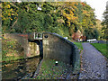
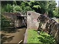
Caldwall Bridge No 12
Next to Caldwell Lock No 5.
Image: © Mat Fascione
Taken: 2 Nov 2020
0.04 miles
2
Caldwall Bridge No 12
Next to Caldwell Lock No 5.
Image: © Mat Fascione
Taken: 21 Jun 2023
0.05 miles
3

Staffordshire and Worcestershire Canal in Kidderminster
Image: © Mat Fascione
Taken: 2 Nov 2020
0.05 miles
4
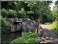
Canal approaching Caldwall Lock, Kidderminster, Worcestershire
Staffordshire and Worcestershire Canal, looking north towards Caldwall Lock, No 12.
Image: © Roger D Kidd
Taken: 23 Aug 2017
0.05 miles
5
Staffordshire and Worcestershire Canal - Caldwall bridge and lock
Image: © Chris Allen
Taken: 5 Dec 2020
0.05 miles
7
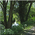
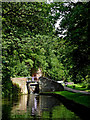
River Stour in Kidderminster, Worcestershire
The River Stour flows southwards here, dividing the town of Kidderminster near Aggborough. This is the view south from the towpath near Caldwall Lock on the Staffordshire and Worcestershire Canal.
Image: © Roger Kidd
Taken: 15 May 2014
0.05 miles
9
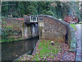
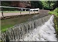
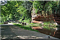
Caldwall Lock west of Aggborough, Kidderminster
Caldwall Lock is on the Staffordshire and Worcestershire Canal between the Aggborough and Foley Park areas of Kidderminster. Navigating southwards it provides a fall of 5ft 6in (about 1·7 metres). The River Stour is close by, off to the left. The canal is cut into an exposure of Early Triassic Kidderminster Formation sandstone rock (formerly known as Bunter Pebble Beds).
Image: © Roger Kidd
Taken: 15 May 2014
0.05 miles
10
Caldwall Lock north-east of Foley Park, Kidderminster
Caldwall Lock is on the Staffordshire and Worcestershire Canal between the Aggborough and Foley Park areas of Kidderminster. Navigating southwards it provides a fall of 5ft 6in (about 1·7 metres). The River Stour is close by, off to the left. The canal is cut into an exposure of Early Triassic Kidderminster Formation sandstone rock (formerly known as Bunter Pebble Beds).
Image: © Roger Kidd
Taken: 15 May 2014
0.05 miles