IMAGES TAKEN NEAR TO
Poplar Road, KIDDERMINSTER, DY11 6NH
Introduction
This page details the photographs taken nearby to Poplar Road, DY11 6NH by members of the Geograph project.
The Geograph project started in 2005 with the aim of publishing, organising and preserving representative images for every square kilometre of Great Britain, Ireland and the Isle of Man.

There are currently over 7.5m images from over14,400 individuals and you can help contribute to the project by visiting https://www.geograph.org.uk
Image Map
Images are licensed for reuse under creativecommons.org/licenses/by-sa/2.0
Notes
- Clicking on the map will re-center to the selected point.
- The higher the marker number, the further away the image location is from the centre of the postcode.
Image Listing (19 Images Found)
Images are licensed for reuse under creativecommons.org/licenses/by-sa/2.0
Image
Details
Distance
1
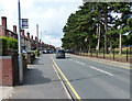
Sutton Road in Kidderminster
On the right is Brinton Park.
Image: © Mat Fascione
Taken: 28 Jul 2013
0.18 miles
2
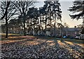
Trees in Brinton Park, Kidderminster
Brinton Park was opened on the 1st August 1887, in the year of Queen Victoria’s Golden Jubilee. John Brinton presented the 23-acre park for the benefit of the ‘townspeople’ of Kidderminster. John Brinton (1827–1914) was an English carpet manufacturer and a Liberal politician, he was born in Kidderminster.
The houses are along Sutton Road.
Image: © Mat Fascione
Taken: 16 Dec 2022
0.22 miles
3
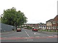
Parry Road, Kidderminster
This road leads off Sutton Park Road, to the Sutton Farm area of Kidderminster. This is a large area of mainly social housing, which was developed from 1929 onwards. Behind the fence on the left, is the site of the demolished Sutton Arms pub, on which a development of detached houses is going to be built.
Image: © P L Chadwick
Taken: 15 Sep 2010
0.23 miles
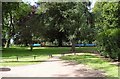
5
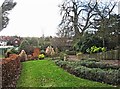
Senses Garden, Brinton Park, Sutton Road, Kidderminster
Part of the Senses Garden (or Sensory Garden) in Brinton Park.
Image
Image: © P L Chadwick
Taken: 9 Dec 2012
0.23 miles
6
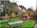
Senses Garden, Brinton Park, Sutton Road, Kidderminster
A view of part of the Senses Garden (or Sensory Garden) in Brinton Park.
Image
Image: © P L Chadwick
Taken: 9 Dec 2012
0.23 miles
7
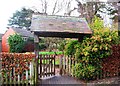
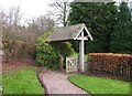
Entrance to the Senses Garden, Brinton Park, Sutton Road, Kidderminster
The Senses Garden (or Sensory Garden) was opened in July 1995 by the late Councillor Michael Oborski, who was at the time Chairman of the Wyre Forest District Council. It is dedicated to the memory of local children who have lost their lives. See also:- Image
Image: © P L Chadwick
Taken: 9 Dec 2012
0.23 miles
8
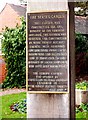
Dedication plaque at entrance to the Senses Garden, Brinton Park, Sutton Road, Kidderminster
This plaque is at the main entrance to the garden, otherwise known as the Sensory Garden, which was constructed for the benefit of people who are sensory impaired.
Image
Image: © P L Chadwick
Taken: 9 Dec 2012
0.23 miles
9
Entrance to the Senses Garden, Brinton Park, Sutton Road, Kidderminster
The main entrance is seen here from inside the garden.
Image
Image: © P L Chadwick
Taken: 9 Dec 2012
0.23 miles
10
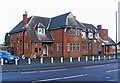
The Sutton Arms, 195 Sutton Park Road, Kidderminster
A huge estate pub serving the Sutton Park area of Kidderminster. It has live music, and a function room which can accommodate 100 people. It is still labelled Banks, although following a series of mergers the company became known as Marston's in 2007.
The long-term future of the pub is uncertain. It was put up for sale by Marston's and later withdrawn from the market. The brewery obtained outline planning permission in March 2009 to demolish the pub, and replace it with between 11 and 14 residential dwellings. The pub is on a large site, with lots of car parking, so there is plenty of space available. There is a limited time period in which the matter can be proceeded with, but currently (December 2009) the pub is still trading. For another view:- Image
Update October 2010:- Sadly the pub has now been demolished, and will be replaced with housing. See:- Image
Image: © P L Chadwick
Taken: 9 Dec 2009
0.24 miles