IMAGES TAKEN NEAR TO
Bridgnorth Road, KIDDERMINSTER, DY11 5RS
Introduction
This page details the photographs taken nearby to Bridgnorth Road, DY11 5RS by members of the Geograph project.
The Geograph project started in 2005 with the aim of publishing, organising and preserving representative images for every square kilometre of Great Britain, Ireland and the Isle of Man.

There are currently over 7.5m images from over14,400 individuals and you can help contribute to the project by visiting https://www.geograph.org.uk
Image Map
Images are licensed for reuse under creativecommons.org/licenses/by-sa/2.0
Notes
- Clicking on the map will re-center to the selected point.
- The higher the marker number, the further away the image location is from the centre of the postcode.
Image Listing (6 Images Found)
Images are licensed for reuse under creativecommons.org/licenses/by-sa/2.0
Image
Details
Distance
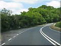
2
Bridgnorth Road between Shatterford and Fairfield
Image: © David Howard
Taken: 30 May 2020
0.05 miles
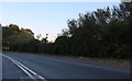
3
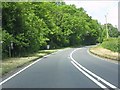
A442 at the entrance to Parkatt Meadows Farm
Image: © Peter Whatley
Taken: 8 Jun 2013
0.07 miles
4
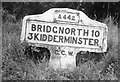
Old Milestone by the A442, north of Parkatt Wood, Kidderminster parish
Concrete post by the A442, in parish of Kidderminster (Wyre Forest District), Parkatt Wood, by the South side of the road.
Lost since 1970.
Inscription reads:-
A442
BRIDGNORTH 10
3 KIDDERMINSTER
C.C.W.
Milestone Society National ID: WO_BNKD09
Image: © Milestone Society
Taken: Unknown
0.11 miles
5
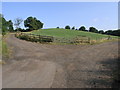
Green Bump
This green field is well served with access tracks. The Worcestershire Way path runs across the top of this square.
Image: © Michael Patterson
Taken: 12 Jul 2006
0.18 miles
6

Park Attwood, dawn view
Spring dawn in the mist, looking east from Park Attwood Clinic towards Wolverley
Image: © Alex Noel-Tod
Taken: 14 Apr 2005
0.23 miles