IMAGES TAKEN NEAR TO
Hollies Lane, KIDDERMINSTER, DY11 5RN
Introduction
This page details the photographs taken nearby to Hollies Lane, DY11 5RN by members of the Geograph project.
The Geograph project started in 2005 with the aim of publishing, organising and preserving representative images for every square kilometre of Great Britain, Ireland and the Isle of Man.

There are currently over 7.5m images from over14,400 individuals and you can help contribute to the project by visiting https://www.geograph.org.uk
Image Map (Loading...)


Getting Data...Please wait
Leaflet Map data © OpenStreetMap
Images are licensed for reuse under creativecommons.org/licenses/by-sa/2.0
Notes
- Clicking on the map will re-center to the selected point.
- The higher the marker number, the further away the image location is from the centre of the postcode.
Image Listing (7 Images Found)
Images are licensed for reuse under creativecommons.org/licenses/by-sa/2.0
Image
Details
Distance
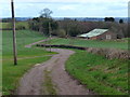
1
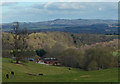
View east to the Clent Hills
The Clent Hills are eight and a half miles away.
In the valley is the Lower Barns Farm.
Image: © Mat Fascione
Taken: 24 Feb 2017
0.04 miles
6
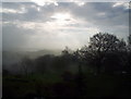
Park Attwood, dawn view
Spring dawn in the mist, looking east from Park Attwood Clinic towards Wolverley
Image: © Alex Noel-Tod
Taken: 14 Apr 2005
0.17 miles