IMAGES TAKEN NEAR TO
Kittiwake Drive, KIDDERMINSTER, DY10 4RS
Introduction
This page details the photographs taken nearby to Kittiwake Drive, DY10 4RS by members of the Geograph project.
The Geograph project started in 2005 with the aim of publishing, organising and preserving representative images for every square kilometre of Great Britain, Ireland and the Isle of Man.

There are currently over 7.5m images from over14,400 individuals and you can help contribute to the project by visiting https://www.geograph.org.uk
Image Map (Loading...)


Getting Data...Please wait
Leaflet Map data © OpenStreetMap
Images are licensed for reuse under creativecommons.org/licenses/by-sa/2.0
Notes
- Clicking on the map will re-center to the selected point.
- The higher the marker number, the further away the image location is from the centre of the postcode.
Image Listing (85 Images Found)
Images are licensed for reuse under creativecommons.org/licenses/by-sa/2.0
Image
Details
Distance
1
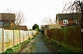
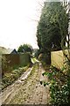
Public footpath between Bittern Wood Road and Kittiwake Drive, Spennells, Kidderminster
Connects two parts of the housing estate, with a lane leading off to Captain's Pool and the Spennells Valley Nature Reserve. This view is looking in the direction of Kittiwake Drive.
Image: © P L Chadwick
Taken: 17 Mar 2013
0.01 miles
2
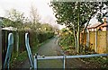
Public footpath between Bittern Wood Road and Kittiwake Drive, Spennells, Kidderminster
Photographed from the barriers near Kittiwake Drive and looking in the direction of Bittern Wood Road. See also:- Image
Image: © P L Chadwick
Taken: 17 Mar 2013
0.02 miles
3
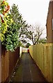
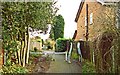
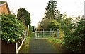
Start of public footpath to Kittiwake Drive, Spennells, Kidderminster
The footpath starts at the end of Bittern Wood Road and comes out on Kittiwake Drive. A continuation path from there goes to Comberton Road (the A448) at the edge of Kidderminster's built-up area. By the red waste bin, seen in the distance, another path branches off to the south and goes down to Captain's Pool and the Spennells Valley Nature Reserve.
Image: © P L Chadwick
Taken: 17 Mar 2013
0.02 miles
4
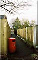
Public footpath between Bittern Wood Road and Kittiwake Drive, Spennells, Kidderminster
Connects two parts of the housing estate, with a lane leading off on the left to Captain's Pool and the Spennells Valley Nature Reserve. This view is looking in the direction of Bittern Wood Road. This is rather an unusual place to locate a waste bin.
Image: © P L Chadwick
Taken: 17 Mar 2013
0.02 miles
5
Lane leading to Captain's Pool, Spennells, Kidderminster
The lane, which is a public footpath, connects a large housing estate with Captain's Pool, a fishing lake, and with Spennells Valley Nature Reserve.
Image: © P L Chadwick
Taken: 17 Mar 2013
0.03 miles
6
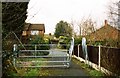
Barriers across footpath near Kittiwake Drive, Spennells, Kidderminster
These barriers are fairly recent and part of a series in this area intended to deter horse riders from using the network of public footpaths. These are not public bridleways, although it appears some people were treating them as such.
Image
Image: © P L Chadwick
Taken: 17 Mar 2013
0.03 miles
7
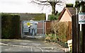
Electricity sub-station, Bittern Wood Road, Spennells, Kidderminster
Located at the end of Bittern Park Road.
Image: © P L Chadwick
Taken: 17 Mar 2013
0.04 miles
8
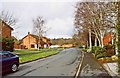
Kittiwake Drive, Spennells, Kidderminster
Part of this residential suburban road.
Image: © P L Chadwick
Taken: 17 Mar 2013
0.05 miles
9
Barriers across footpath near Kittiwake Drive, Spennells, Kidderminster
This public footpath runs from Kittiwake Drive to Comberton Road (part of the A448) on the edge of the town. The barriers are intended to deter horse riders.
Image
Image: © P L Chadwick
Taken: 17 Mar 2013
0.05 miles
10
Barriers across footpath near Kittiwake Drive, Spennells, Kidderminster
The barriers are to deter horse riders using the public footpath. See also:- Image
Image: © P L Chadwick
Taken: 17 Mar 2013
0.05 miles