IMAGES TAKEN NEAR TO
Brockencote, KIDDERMINSTER, DY10 4PR
Introduction
This page details the photographs taken nearby to Brockencote, DY10 4PR by members of the Geograph project.
The Geograph project started in 2005 with the aim of publishing, organising and preserving representative images for every square kilometre of Great Britain, Ireland and the Isle of Man.

There are currently over 7.5m images from over14,400 individuals and you can help contribute to the project by visiting https://www.geograph.org.uk
Image Map (Loading...)


Getting Data...Please wait
Leaflet Map data © OpenStreetMap
Images are licensed for reuse under creativecommons.org/licenses/by-sa/2.0
Notes
- Clicking on the map will re-center to the selected point.
- The higher the marker number, the further away the image location is from the centre of the postcode.
Image Listing (6 Images Found)
Images are licensed for reuse under creativecommons.org/licenses/by-sa/2.0
Image
Details
Distance

2
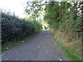
Lane to a farm from Dobes Lane, Chaddesley Corbett
Image: © Jeff Gogarty
Taken: 18 Sep 2016
0.17 miles
3
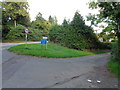
Dobes Lane leaves the A448, Chaddesley Corbett
Image: © Jeff Gogarty
Taken: 18 Sep 2016
0.17 miles
4
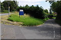
Dobes Lane
Dobes Lane junction with the A448 to the west of Chaddesley Corbett.
Image: © Philip Halling
Taken: 22 Jul 2012
0.18 miles
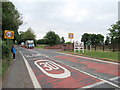
6
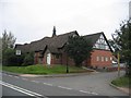
Chaddesley Corbett Village Hall
The hall is in Brockencote and was built in 1895 and much extended recently for the millennium.
Image: © David Stowell
Taken: 30 Apr 2006
0.23 miles