IMAGES TAKEN NEAR TO
Briar Hill, KIDDERMINSTER, DY10 4NW
Introduction
This page details the photographs taken nearby to Briar Hill, DY10 4NW by members of the Geograph project.
The Geograph project started in 2005 with the aim of publishing, organising and preserving representative images for every square kilometre of Great Britain, Ireland and the Isle of Man.

There are currently over 7.5m images from over14,400 individuals and you can help contribute to the project by visiting https://www.geograph.org.uk
Image Map
Images are licensed for reuse under creativecommons.org/licenses/by-sa/2.0
Notes
- Clicking on the map will re-center to the selected point.
- The higher the marker number, the further away the image location is from the centre of the postcode.
Image Listing (9 Images Found)
Images are licensed for reuse under creativecommons.org/licenses/by-sa/2.0
Image
Details
Distance
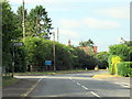
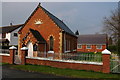
2
Methodist Church , Bluntington, Worcs
Image: © Richard Rogerson
Taken: 30 Oct 2010
0.11 miles
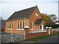
4
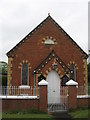
Methodist Chapel, Bluntington, Worcestershire
A stone above the door says the chapel was erected in 1873
Image: © Richard Rogerson
Taken: 29 May 2010
0.12 miles
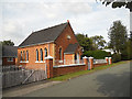
5
Methodist Chapel, Bluntington near Chaddesley Corbett
The engraving above the entrance states that this Methodist Chapel was erected in 1875.
Image: © Philip Halling
Taken: 31 Mar 2007
0.13 miles