IMAGES TAKEN NEAR TO
Curslow Lane, KIDDERMINSTER, DY10 4LF
Introduction
This page details the photographs taken nearby to Curslow Lane, DY10 4LF by members of the Geograph project.
The Geograph project started in 2005 with the aim of publishing, organising and preserving representative images for every square kilometre of Great Britain, Ireland and the Isle of Man.

There are currently over 7.5m images from over14,400 individuals and you can help contribute to the project by visiting https://www.geograph.org.uk
Image Map (Loading...)


Getting Data...Please wait
Leaflet Map data © OpenStreetMap
Images are licensed for reuse under creativecommons.org/licenses/by-sa/2.0
Notes
- Clicking on the map will re-center to the selected point.
- The higher the marker number, the further away the image location is from the centre of the postcode.
Image Listing (8 Images Found)
Images are licensed for reuse under creativecommons.org/licenses/by-sa/2.0
Image
Details
Distance
2
Pond and Greenhouses from Back Lane, Mustow Green
The greenhouses must be fairly recent as they do not appear on street view. It does appear there were Image there 15 years ago and new ones appearing Image 8 years ago. Many more now.
Image: © Jeff Gogarty
Taken: 8 Jan 2021
0.07 miles
3
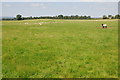
Sheep in a field near Shenstone
Sheep in a field to the east of Shenstone.
Image: © Philip Halling
Taken: 22 Jul 2012
0.09 miles
5
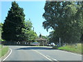
A448 Kidderminster Road passing entrance to Winterfold School
Image: © Roy Hughes
Taken: 25 Jun 2020
0.16 miles
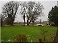
6
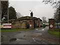
Top Lodge, Winterfold House School, Chaddesley Corbett
Image: © Jeff Gogarty
Taken: 8 Jan 2021
0.16 miles
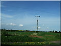
7
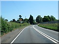
A448 Kidderminster Road near Mustow Green
Image: © Roy Hughes
Taken: 25 Jun 2020
0.16 miles
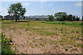
8
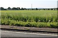
Field by Bromsgrove Road, Mustow Green
Image: © David Howard
Taken: 30 May 2020
0.18 miles