IMAGES TAKEN NEAR TO
Teal Crescent, KIDDERMINSTER, DY10 4ET
Introduction
This page details the photographs taken nearby to Teal Crescent, DY10 4ET by members of the Geograph project.
The Geograph project started in 2005 with the aim of publishing, organising and preserving representative images for every square kilometre of Great Britain, Ireland and the Isle of Man.

There are currently over 7.5m images from over14,400 individuals and you can help contribute to the project by visiting https://www.geograph.org.uk
Image Map (Loading...)


Getting Data...Please wait
Leaflet Map data © OpenStreetMap
Images are licensed for reuse under creativecommons.org/licenses/by-sa/2.0
Notes
- Clicking on the map will re-center to the selected point.
- The higher the marker number, the further away the image location is from the centre of the postcode.
Image Listing (92 Images Found)
Images are licensed for reuse under creativecommons.org/licenses/by-sa/2.0
Image
Details
Distance
1
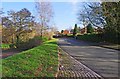
Heronswood Road, Spennells, Kidderminster
On the left is part of a public car park serving visitors to the local nature reserve and sports and play facilities.
Image
Image: © P L Chadwick
Taken: 30 Jan 2013
0.02 miles
2
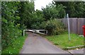
Lane from Heronswood Road to the Sports Ground, Spennells, Kidderminster
Connecting lane which is also a public footpath. Can also be used by authorised vehicles which have the key to the barrier.
Image
Image: © P L Chadwick
Taken: 4 Aug 2013
0.03 miles
3
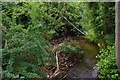
Hoo Brook, Spennells, Kidderminster
The Hoo Brook is seen here from the bridge carrying the short connecting lane between Heronswood Road and the Sports Ground.
Image: © P L Chadwick
Taken: 4 Aug 2013
0.04 miles
4
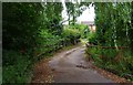
Lane from Sports Ground to Heronswood Road, Spennells, Kidderminster
Connecting lane with bridge, which crosses the Hoo Brook. The lane is also a public footpath.
Image
Image: © P L Chadwick
Taken: 4 Aug 2013
0.04 miles
5
Hoo Brook, looking east, Kidderminster
On the left is the sports ground or playing field, which is adjacent to parts of the Spennells Valley Nature Reserve.
Image: © P L Chadwick
Taken: 30 Jan 2013
0.05 miles
6
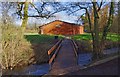
Footbridge over the Hoo Brook, from Spennells Valley Nature Reserve car park, Kidderminster
The footbridge links the car park to the sports or playing field and adjacent play area. The back of the changing rooms can also be seen in this view.
Image: © P L Chadwick
Taken: 30 Jan 2013
0.05 miles
7
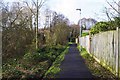
Path at the edge of Spennells Valley Nature Reserve, Spennells, Kidderminster
The path in this direction comes out on Heronswood Road. It runs behind some houses, along the edge of this part of the nature reserve.
Image
Image: © P L Chadwick
Taken: 30 Jan 2013
0.05 miles
8
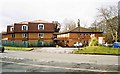
Herons Park Nursing Home, Heronswood Road, Spennells, Kidderminster
This is a care home registered for 58 persons. It was acquired by Royal Bay Care Homes in 2006.
Image: © P L Chadwick
Taken: 17 Mar 2013
0.05 miles
9
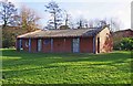
Changing Rooms, Sports Field, Spennells, Kidderminster
Located near the footbridge over Hoo Brook, which is adjacent to the public car park off Heronswood Road.
Image
Image: © P L Chadwick
Taken: 30 Jan 2013
0.06 miles
10
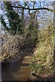
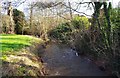
Hoo Brook, looking west, Kidderminster
The Hoo Brook is a tributary of the River Stour, which discharges into the River Severn at Stourport-on-Severn.
Image: © P L Chadwick
Taken: 30 Jan 2013
0.06 miles