IMAGES TAKEN NEAR TO
Heath Lane, KIDDERMINSTER, DY10 4BL
Introduction
This page details the photographs taken nearby to Heath Lane, DY10 4BL by members of the Geograph project.
The Geograph project started in 2005 with the aim of publishing, organising and preserving representative images for every square kilometre of Great Britain, Ireland and the Isle of Man.

There are currently over 7.5m images from over14,400 individuals and you can help contribute to the project by visiting https://www.geograph.org.uk
Image Map
Images are licensed for reuse under creativecommons.org/licenses/by-sa/2.0
Notes
- Clicking on the map will re-center to the selected point.
- The higher the marker number, the further away the image location is from the centre of the postcode.
Image Listing (8 Images Found)
Images are licensed for reuse under creativecommons.org/licenses/by-sa/2.0
Image
Details
Distance
1
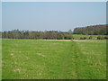
Around Stanklyn
Picture taken looking east along the public footpath leading to Stanklyn Lane, from grid reference SO85175 74444, directly under the power lines. Stanklyn Wood can be seen on the higher ground to the right of the picture, and the spire of Stone Church (see image in adjacent square) is just visible above the tree-line towards the left.
Image: © Martyn B
Taken: 2 Apr 2005
0.15 miles
2
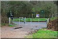
Gates onto Stanklyn Lane, near Spennells, Kidderminster, Worcs
My dog enjoyed his walk on New Year's Day in fields near Spennells. Here the public footpath passes to the left of the gates and comes out on Stanklyn Lane. There used to be a stile at this point but that has now gone.
The stile can be seen in this photograph dating from September 2013 and taken from the Stanklyn Lane side of the gates. The red dog waste bin has been replaced by a black one and in 2013 the public footpath sign was standing upright rather than at an angle. Image
Image: © P L Chadwick
Taken: 1 Jan 2022
0.15 miles
3
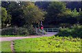
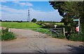
End of public footpath at Stanklyn Lane, near Stone, Worcs
The public footpath is the path in the foreground which then turns right to run a few feet along the track. Stanklyn Lane is the other side of the gate.
Image
Image: © P L Chadwick
Taken: 29 Sep 2013
0.16 miles
4
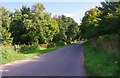
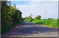
Stanklyn Lane, near Stone, Worcs
In this direction Stanklyn Lane eventually meets the A448 road at Stone.
Image: © P L Chadwick
Taken: 29 Sep 2013
0.16 miles
5
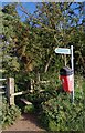
Stile, public footpath sign and dog waste bin, Stanklyn Lane, near Stone, Worcs
It's unusual to find a dog waste bin in a rural spot like this, especially as many places which would benefit from one don't have one.
Image
Image: © P L Chadwick
Taken: 29 Sep 2013
0.16 miles
6
Stanklyn Lane, near Stone, Worcs
In this direction the road is heading for its junction with Worcester Road (the A449).
Image: © P L Chadwick
Taken: 29 Sep 2013
0.16 miles
7
The start of a public footpath from Stanklyn Lane, near Stone, Worcs
The footpath starts at the stile by the gate and goes left. It joins other paths later on, from which it is possible to walk to Captains Pool, the Spennells Valley Nature Reserve, and the Spennells housing estate on the edge of Kidderminster. The electricity pylon is one of several around here.
Image
Image: © P L Chadwick
Taken: 29 Sep 2013
0.16 miles
8
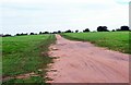
Track across a field, near Stone, Worcs
There is no public right of way over this track apart from the first few feet near the gate to Stanklyn Lane (behind the camera position).
Image
Image: © P L Chadwick
Taken: 29 Sep 2013
0.20 miles