IMAGES TAKEN NEAR TO
Kingfisher Grove, KIDDERMINSTER, DY10 4AG
Introduction
This page details the photographs taken nearby to Kingfisher Grove, DY10 4AG by members of the Geograph project.
The Geograph project started in 2005 with the aim of publishing, organising and preserving representative images for every square kilometre of Great Britain, Ireland and the Isle of Man.

There are currently over 7.5m images from over14,400 individuals and you can help contribute to the project by visiting https://www.geograph.org.uk
Image Map
Images are licensed for reuse under creativecommons.org/licenses/by-sa/2.0
Notes
- Clicking on the map will re-center to the selected point.
- The higher the marker number, the further away the image location is from the centre of the postcode.
Image Listing (38 Images Found)
Images are licensed for reuse under creativecommons.org/licenses/by-sa/2.0
Image
Details
Distance
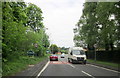
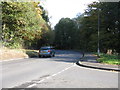
2
Spennells Valley Road meets Comberton Road
Image: © Peter Whatley
Taken: 26 Oct 2011
0.07 miles
3
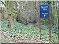
Spennells Valley Nature Reserve
A nature reserve situated within an extensive housing development. Picture taken looking west into the reserve from grid reference SO84790 75310, a few metres west of the A448.
Image: © Martyn B
Taken: 25 Mar 2005
0.08 miles
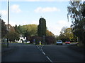
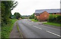
5
Spennells Valley Road from Heronswood Road
Image: © Peter Whatley
Taken: 26 Oct 2011
0.09 miles
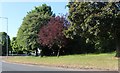
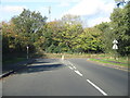
6
Comberton Road approaching roundabout, Kidderminster
Comberton Road here forms part of the A448. The nearby roundabout is at the junction of the road with Spennells Valley Road and a service road.
Image: © P L Chadwick
Taken: 4 Aug 2013
0.11 miles
8
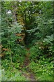
Path from Comberton Road to Heronswood Road, Spennells, Kidderminster
This is the start of the path at Comberton Road (part of the A448). The path goes through a wooded area, part of Spennells Valley Nature Reserve, and is near to and often adjacent to the Hoo Brook.
Image: © P L Chadwick
Taken: 4 Aug 2013
0.13 miles
9
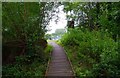
Boardwalk in Spennells Valley Nature Reserve, Spennells, Kidderminster
Some sections of footpath in the nature reserve are on boardwalk. This section starts at Heronswood Road, which is in the distance.
Image: © P L Chadwick
Taken: 4 Aug 2013
0.13 miles
10
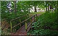
Footbridge over Hoo Brook, Spennells, Kidderminster
This footbridge in the Spennells Valley Nature Reserve takes a footpath across the Hoo Brook. The path connects with Cardinal Drive.
Image
Image: © P L Chadwick
Taken: 4 Aug 2013
0.14 miles