IMAGES TAKEN NEAR TO
Birmingham Road, KIDDERMINSTER, DY10 3LH
Introduction
This page details the photographs taken nearby to Birmingham Road, DY10 3LH by members of the Geograph project.
The Geograph project started in 2005 with the aim of publishing, organising and preserving representative images for every square kilometre of Great Britain, Ireland and the Isle of Man.

There are currently over 7.5m images from over14,400 individuals and you can help contribute to the project by visiting https://www.geograph.org.uk
Image Map
Images are licensed for reuse under creativecommons.org/licenses/by-sa/2.0
Notes
- Clicking on the map will re-center to the selected point.
- The higher the marker number, the further away the image location is from the centre of the postcode.
Image Listing (22 Images Found)
Images are licensed for reuse under creativecommons.org/licenses/by-sa/2.0
Image
Details
Distance
1
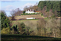
Harborough Hill
Looking across to Harborough Hill House. A lorry heading along the A456 can also be seen in the picture.
Image: © Stephen McKay
Taken: 27 Jan 2022
0.01 miles
2
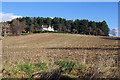
Harborough Hill
Looking up to the wooded top of Harborough Hill with Harborough Hill House looking down.
Image: © Stephen McKay
Taken: 27 Jan 2022
0.02 miles
3
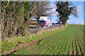
Heading down Birmingham Road
A Scania truck belonging to Devereux Transport and Distribution thunders along the A456 down the side of Harborough Hill between Hagley and Blakedown. Devereux is a large haulage company, whose business grew out of house removals, based on Teesside. The trailer is advertising Shreddies, a breakfast cereal manufactured by Nestlé in Wiltshire. This operation is probably part of a complicated distribution chain.
Image: © Stephen McKay
Taken: 27 Jan 2022
0.11 miles
4
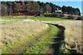
Track to Harborough Hill
The track leads of a bridleway but is not itself a public right of way. Harborough Hill House can be seen ahead.
Image: © Stephen McKay
Taken: 27 Jan 2022
0.13 miles
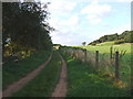
5
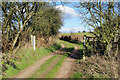
Bridleway to Stakenbridge
The bridleway from Blakedown heads round the western side of Harborough Hill.
Image: © Stephen McKay
Taken: 27 Jan 2022
0.14 miles
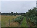
6
Bridleway leading from Stakenbridge to Blakedown
Image: © Chris Whippet
Taken: 14 Feb 2015
0.15 miles
7
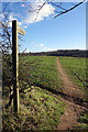
Path towards Broome
The wooden signpost points the way along a clearly defined public footpath leading off the A456 Birmingham Road.
Image: © Stephen McKay
Taken: 27 Jan 2022
0.15 miles
9
Bridleway leading from Blakedown to Stakenbridge
Image: © Chris Whippet
Taken: 22 Aug 2013
0.16 miles
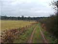
10
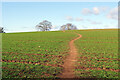
Path towards Harborough Hill
The path is well-defined but does seem to wander around in a slightly drunken fashion.
Image: © Stephen McKay
Taken: 27 Jan 2022
0.19 miles