IMAGES TAKEN NEAR TO
Towers Close, KIDDERMINSTER, DY10 3EH
Introduction
This page details the photographs taken nearby to Towers Close, DY10 3EH by members of the Geograph project.
The Geograph project started in 2005 with the aim of publishing, organising and preserving representative images for every square kilometre of Great Britain, Ireland and the Isle of Man.

There are currently over 7.5m images from over14,400 individuals and you can help contribute to the project by visiting https://www.geograph.org.uk
Image Map (Loading...)


Getting Data...Please wait
Leaflet Map data © OpenStreetMap
Images are licensed for reuse under creativecommons.org/licenses/by-sa/2.0
Notes
- Clicking on the map will re-center to the selected point.
- The higher the marker number, the further away the image location is from the centre of the postcode.
Image Listing (10 Images Found)
Images are licensed for reuse under creativecommons.org/licenses/by-sa/2.0
Image
Details
Distance
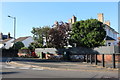
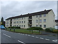
3
Borrington Road, Kidderminster
Looking north east.
Image: © JThomas
Taken: 8 Jun 2019
0.15 miles
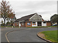
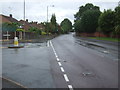
6
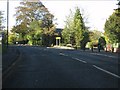
Comberton Road (A448) at Somerleyton Avenue
Image: © Peter Whatley
Taken: 26 Oct 2011
0.16 miles
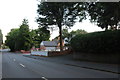
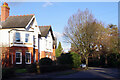
7
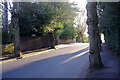
Hill Grove Crescent, Kidderminster
Leading off Comberton Road, Hill Grove Crescent is a leafy residential street lined with substantial houses.
Image: © Stephen McKay
Taken: 27 Jan 2022
0.17 miles
9
Hill Grove Crescent, Kidderminster
Hill Grove Crescent runs in a rough arc between Chester Road South and Comberton Road. It is a leafy area with substantial houses.
Image: © Stephen McKay
Taken: 27 Jan 2022
0.23 miles
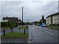
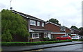
10
Comberton Road, Kidderminster
Looking south east on the A448.
Image: © JThomas
Taken: 8 Jun 2019
0.23 miles