IMAGES TAKEN NEAR TO
Comberton Road, KIDDERMINSTER, DY10 3DP
Introduction
This page details the photographs taken nearby to Comberton Road, DY10 3DP by members of the Geograph project.
The Geograph project started in 2005 with the aim of publishing, organising and preserving representative images for every square kilometre of Great Britain, Ireland and the Isle of Man.

There are currently over 7.5m images from over14,400 individuals and you can help contribute to the project by visiting https://www.geograph.org.uk
Image Map
Images are licensed for reuse under creativecommons.org/licenses/by-sa/2.0
Notes
- Clicking on the map will re-center to the selected point.
- The higher the marker number, the further away the image location is from the centre of the postcode.
Image Listing (36 Images Found)
Images are licensed for reuse under creativecommons.org/licenses/by-sa/2.0
Image
Details
Distance
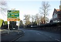
1
Comberton Road (A448) at Somerleyton Avenue
Image: © Peter Whatley
Taken: 26 Oct 2011
0.02 miles
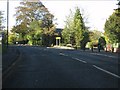
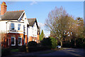
3
Hill Grove Crescent, Kidderminster
Leading off Comberton Road, Hill Grove Crescent is a leafy residential street lined with substantial houses.
Image: © Stephen McKay
Taken: 27 Jan 2022
0.08 miles
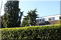
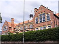
4
King Charles I School, Kidderminster
This is the only school in the UK to be named after King Charles I, although its origins pre-date his reign. It was founded by Thomas Blount, Lord of the Manor of Kidderminster, in about 1566 and given its royal charter by Charles I in 1636. It amalgamated with Queen Elizabeth I Grammar School at Hartlebury and Kidderminster High School for Girls in 1977 when it became established on its present site (although the lowest two years have separate premises nearby). The school now has academy status.
Image: © Stephen McKay
Taken: 27 Jan 2022
0.09 miles
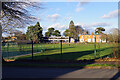
5
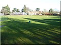
Playing field, King Charles I School
Playing field at King Charles I School in Kidderminster. The school's website states this is the only secondary school, in the United Kingdom, to bear the name of King Charles I. The king gave a charter to the school in 1636, though it was actually founded by Thomas Blount, esq., Lord of the Manor of Kidderminster, some 70 years earlier.
Image: © Philip Halling
Taken: 26 Jan 2018
0.09 miles
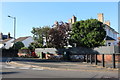
6
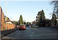
Chester Road meets Comberton Road, Kidderminster
Or, if you prefer, the A449 meets the A448. Severn Valley Railway to the left, but I'm heading right now the cars have passed.
Image: © Peter Whatley
Taken: 3 Jan 2009
0.11 miles
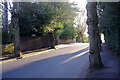
7
Hill Grove Crescent, Kidderminster
Hill Grove Crescent runs in a rough arc between Chester Road South and Comberton Road. It is a leafy area with substantial houses.
Image: © Stephen McKay
Taken: 27 Jan 2022
0.11 miles
8
Flats on Comberton Road, Kidderminster
Image: © David Howard
Taken: 30 May 2020
0.13 miles
9
Chester Road (A449) at Pelham Lodge junction
Nearly at the Severn Valley Railway!
Image: © Peter Whatley
Taken: 3 Jan 2009
0.13 miles
10
King Charles I School
The view of the Kidderminster School in Chester Road South.
Image: © Gordon Griffiths
Taken: 7 Jul 2017
0.14 miles