IMAGES TAKEN NEAR TO
Linden Gardens, KIDDERMINSTER, DY10 3BF
Introduction
This page details the photographs taken nearby to Linden Gardens, DY10 3BF by members of the Geograph project.
The Geograph project started in 2005 with the aim of publishing, organising and preserving representative images for every square kilometre of Great Britain, Ireland and the Isle of Man.

There are currently over 7.5m images from over14,400 individuals and you can help contribute to the project by visiting https://www.geograph.org.uk
Image Map
Images are licensed for reuse under creativecommons.org/licenses/by-sa/2.0
Notes
- Clicking on the map will re-center to the selected point.
- The higher the marker number, the further away the image location is from the centre of the postcode.
Image Listing (38 Images Found)
Images are licensed for reuse under creativecommons.org/licenses/by-sa/2.0
Image
Details
Distance
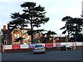
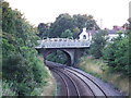
3

Chester Road North Railway End 3
Photo taken by me at Day 2 of the Vitality County Championship match between Worcestershire CCC and Durham CCC on 20 April 2024 at the Chester Road North Ground, Kidderminster. The Railway End.
Image: © FieldOfWheat
Taken: 20 Apr 2024
0.08 miles
7
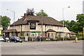
The Land Oak public house
On Chester Road North, Kidderminster.
Image: © Ian S
Taken: 26 May 2014
0.12 miles
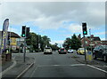
10
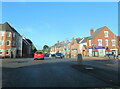
The A456 west at Chester Road North crossroads
Image: © Roy Hughes
Taken: 1 Oct 2022
0.12 miles