IMAGES TAKEN NEAR TO
Pelham Lodge, KIDDERMINSTER, DY10 1XR
Introduction
This page details the photographs taken nearby to Pelham Lodge, DY10 1XR by members of the Geograph project.
The Geograph project started in 2005 with the aim of publishing, organising and preserving representative images for every square kilometre of Great Britain, Ireland and the Isle of Man.

There are currently over 7.5m images from over14,400 individuals and you can help contribute to the project by visiting https://www.geograph.org.uk
Image Map
Images are licensed for reuse under creativecommons.org/licenses/by-sa/2.0
Notes
- Clicking on the map will re-center to the selected point.
- The higher the marker number, the further away the image location is from the centre of the postcode.
Image Listing (449 Images Found)
Images are licensed for reuse under creativecommons.org/licenses/by-sa/2.0
Image
Details
Distance
1
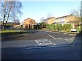
Entrance to Pelham Lodge
Entrance to Pelham Lodge of Chester Road South in Kidderminster.
Image: © Philip Halling
Taken: 26 Jan 2018
0.02 miles
2
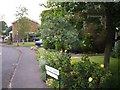
Pelham Lodge, Kidderminster
Looking north-west.
Image: © Kenneth Allen
Taken: 8 Jun 2007
0.02 miles
3
Chester Road South, Kidderminster
Looking south west on the A449.
Image: © JThomas
Taken: 8 Jun 2019
0.03 miles
4
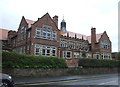
King Charles I School, Kidderminster
Mixed secondary school with academy status.
Image: © JThomas
Taken: 8 Jun 2019
0.04 miles
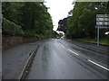
5
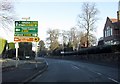
Chester Road (A449) at Pelham Lodge junction
Nearly at the Severn Valley Railway!
Image: © Peter Whatley
Taken: 3 Jan 2009
0.05 miles
6
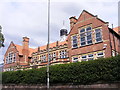
King Charles I School
The view of the Kidderminster School in Chester Road South.
Image: © Gordon Griffiths
Taken: 7 Jul 2017
0.05 miles
7
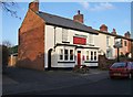
The Station Inn, 7 Farfield
This is one of several public houses in Kidderminster whose name has a railway connection. Until some years ago it was known as the Railway Station Inn, but today it is called The Station Inn. It has been a pub since at least the 1840's. There are no windows in the end wall because originally there were three terraced houses adjoining it. Around the middle of the 20th century these were demolished to provide space for a car park for the inn.
Image: © P L Chadwick
Taken: 28 Dec 2008
0.06 miles
8
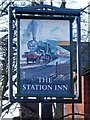
The Station Inn pub sign, 7 Farfield
This was originally known as The Railway Station Inn but at some point it was shortened to the present name. Enlarging this photograph seems to indicate that the original name may have been erased and painted over with the new name. If so, then this rather faded sign, showing as it does a steam hauled train, may be quite old.
Image: © P L Chadwick
Taken: 28 Dec 2008
0.06 miles
9
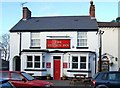
The Station Inn, 7 Farfield
Originally known as The Railway Station Inn, today this pub serves lunchtime and evening meals and has an enclosed rear garden. The arch on the left originally led to a stable block for horses. The building has been a pub since at least the 1840's. Image Image
Image: © P L Chadwick
Taken: 28 Dec 2008
0.06 miles
10
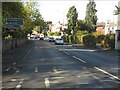
Comberton Road (A448) approaching Chester Road
Image: © Peter Whatley
Taken: 26 Oct 2011
0.07 miles