IMAGES TAKEN NEAR TO
College Walk, KIDDERMINSTER, DY10 1PL
Introduction
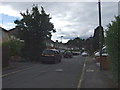
This page details the photographs taken nearby to College Walk, DY10 1PL by members of the Geograph project.
The Geograph project started in 2005 with the aim of publishing, organising and preserving representative images for every square kilometre of Great Britain, Ireland and the Isle of Man.

There are currently over 7.5m images from over14,400 individuals and you can help contribute to the project by visiting https://www.geograph.org.uk
Image Map (Loading...)


Getting Data...Please wait
Leaflet Map data © OpenStreetMap
Images are licensed for reuse under creativecommons.org/licenses/by-sa/2.0
Notes
- Clicking on the map will re-center to the selected point.
- The higher the marker number, the further away the image location is from the centre of the postcode.
Image Listing (108 Images Found)
Images are licensed for reuse under creativecommons.org/licenses/by-sa/2.0
Image
Details
Distance
2
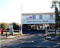
Jubilee Community Church Kidderminster
Viewed across Hoo Road. The church, part of the Elim Pentecostal congregation, is adjacent to the south side of Aggborough Stadium, the home ground of Kidderminster Harriers F.C.
Image: © Jaggery
Taken: 22 Sep 2012
0.10 miles
3
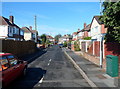
Griffin Avenue, Kidderminster
A 100 metre long cul-de-sac on the west side of Hoo Road.
Aggborough Stadium, the home ground of Kidderminster Harriers F.C., is behind the camera.
Image: © Jaggery
Taken: 22 Sep 2012
0.11 miles
5
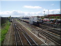
Severn Valley & mainline railways, Kidderminster
Looking South from the footbridge at SO 83727 75926, a steam train slowly makes its way along the last few hundred metres into the Severn Valley railway station in Kidderminster. On the left is the main line between Kidderminster & Worcester. Towards the top right of the picture is the back of the stand at Kidderminster Harriers Football Club.
Image: © Martyn B
Taken: 6 Apr 2005
0.13 miles
6
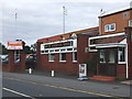
The Harriers Arms, Kidderminster
Located next to the Kidderminster Harriers ground.
Image: © Chris Whippet
Taken: 24 Aug 2013
0.14 miles
7
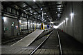
The Carriage Shed, Severn Valley Railway
At a third of a mile in length, the shed was built to protect the railway's fleet of more than 60 historic coaches from the elements and to provide under cover cleaning and maintenance facilities. This magnificent building has no equals, either in the heritage world or on the 'real' railway. Looking towards Kidderminster. Open to the public during the Peep Behind the Scenes event of 15th July.
Image: © Philip Pankhurst
Taken: 15 Jul 2017
0.14 miles
8
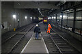
Severn Valley Railway - carriage wash
This is a well hidden piece of infrastructure that is screened from the running lines by the huge carriage shed. This was only visible because I had paid to go on a guided tour of the diesel depot and carriage shed. Excellent value and I would do it again. Our guides were leisurely, informative and accommodating - what more could you want?
Image: © Chris Allen
Taken: 2 Oct 2022
0.14 miles
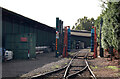
9
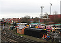
Sidings at Kidderminster
Storage area for preserved railway rolling stock.
Image: © Peter Langsdale
Taken: 7 Mar 2009
0.14 miles
10
Severn Valley Railway - carriage shed
This is claimed to be the biggest single storey building in Kidderminster and I can believe it. This is moving down from the platform to track level towards the far end where there are stored locomotive and carriages. This is a fantastic facility for the railway and helps keep the weather off rolling stock and allows for servicing and maintenance under cover. This was a special guided tour. The building is just not suitable for routine public access.
Image: © Chris Allen
Taken: 2 Oct 2022
0.15 miles