IMAGES TAKEN NEAR TO
Mill Lane, SHERBORNE, DT9 6RH
Introduction
This page details the photographs taken nearby to Mill Lane, DT9 6RH by members of the Geograph project.
The Geograph project started in 2005 with the aim of publishing, organising and preserving representative images for every square kilometre of Great Britain, Ireland and the Isle of Man.

There are currently over 7.5m images from over14,400 individuals and you can help contribute to the project by visiting https://www.geograph.org.uk
Image Map (Loading...)


Getting Data...Please wait
Leaflet Map data © OpenStreetMap
Images are licensed for reuse under creativecommons.org/licenses/by-sa/2.0
Notes
- Clicking on the map will re-center to the selected point.
- The higher the marker number, the further away the image location is from the centre of the postcode.
Image Listing (114 Images Found)
Images are licensed for reuse under creativecommons.org/licenses/by-sa/2.0
Image
Details
Distance
1
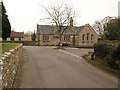
St Mary?s Church of England Voluntary Controlled Primary School, Bradford Abbas
This Victorian building was opened on Easter Monday in 1856; there is a larger newer building, opened 110 years later, behind to the right. On the left is the churchyard wall.
Image: © Derek Harper
Taken: 12 Feb 2010
0.02 miles
2
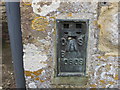
Ordnance Survey Flush Bracket 10809
This can be found on the roadside wall of St Mary's School.
For more detail see : http://www.bench-marks.org.uk/bm18802
Image: © Peter Wood
Taken: 31 Mar 2014
0.03 miles
3

Bradford Abbas: Mill Lane
Towards Bradford Abbas Mill. Now a residence this was a water-powered flax mill in the first half of the nindeteenth century. The millhouse is seen here; the mill, converted to grind grain by 1851, is out of sight, round the bend
Image: © Martin Bodman
Taken: 15 Jul 2012
0.04 miles
4

Bradford Abbas: towards the churchyard
Seen from the end of Mill Lane
Image: © Martin Bodman
Taken: 15 Jul 2012
0.04 miles
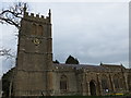
5
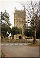
Bradford Abbas: church
The west tower
Image: © Martin Bodman
Taken: 27 Apr 1991
0.04 miles
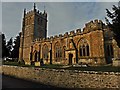
6
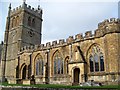
The Church of St Mary, Bradford Abbas
The church has its origins in the 12th century. It has rubble walls and dressings of Ham Hill stone. The roof is stone slates.
Image: © Maigheach-gheal
Taken: 31 Oct 2009
0.04 miles
7
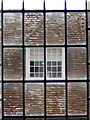
Bradford Abbas: windows through windows
A view through the church window towards a dormer of St. Mary's House, an 18th century former vicarage.
Image: © Chris Downer
Taken: 27 Mar 2014
0.05 miles
9

Bradford Abbas: churchyard with Yew trees
Image: © Martin Bodman
Taken: 15 Jul 2012
0.05 miles
10
The Church of St Mary at Bradford Abbas
Viewed from the south.
Image: © Peter Wood
Taken: 31 Mar 2014
0.05 miles