IMAGES TAKEN NEAR TO
The Terrace, Pound Road, SHERBORNE, DT9 6QA
Introduction
This page details the photographs taken nearby to The Terrace, Pound Road, DT9 6QA by members of the Geograph project.
The Geograph project started in 2005 with the aim of publishing, organising and preserving representative images for every square kilometre of Great Britain, Ireland and the Isle of Man.

There are currently over 7.5m images from over14,400 individuals and you can help contribute to the project by visiting https://www.geograph.org.uk
Image Map
Images are licensed for reuse under creativecommons.org/licenses/by-sa/2.0
Notes
- Clicking on the map will re-center to the selected point.
- The higher the marker number, the further away the image location is from the centre of the postcode.
Image Listing (134 Images Found)
Images are licensed for reuse under creativecommons.org/licenses/by-sa/2.0
Image
Details
Distance
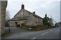
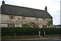
2
Grey Cottage
Grade II listed. https://historicengland.org.uk/listing/the-list/list-entry/1303874
Image: © N Chadwick
Taken: 28 Dec 2018
0.02 miles
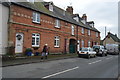
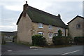
3
Pyt House
Grade II listed. https://historicengland.org.uk/listing/the-list/list-entry/1119343
Image: © N Chadwick
Taken: 28 Dec 2018
0.02 miles
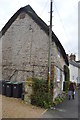
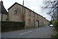
4
Greenhill Dairy House
Grade II listed. https://historicengland.org.uk/listing/the-list/list-entry/1262353
Image: © N Chadwick
Taken: 28 Dec 2018
0.03 miles

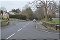
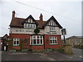
8
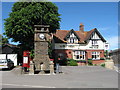
Clock Tower and Public House, Thornford village centre
Image: © william
Taken: 2 Jun 2007
0.06 miles