IMAGES TAKEN NEAR TO
Thornford Road, SHERBORNE, DT9 6PT
Introduction
This page details the photographs taken nearby to Thornford Road, DT9 6PT by members of the Geograph project.
The Geograph project started in 2005 with the aim of publishing, organising and preserving representative images for every square kilometre of Great Britain, Ireland and the Isle of Man.

There are currently over 7.5m images from over14,400 individuals and you can help contribute to the project by visiting https://www.geograph.org.uk
Image Map
Images are licensed for reuse under creativecommons.org/licenses/by-sa/2.0
Notes
- Clicking on the map will re-center to the selected point.
- The higher the marker number, the further away the image location is from the centre of the postcode.
Image Listing (7 Images Found)
Images are licensed for reuse under creativecommons.org/licenses/by-sa/2.0
Image
Details
Distance
2
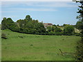
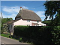
Lake Farm and cottages
Valley with small meandering stream in foreground.
Image: © william
Taken: 2 Jun 2007
0.03 miles
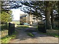
3
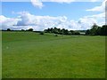
Lake, Thornford, Dorset
Lake is a small cluster of houses round Lake Farm. The lake it refers to is more of a large pond. This is the view north east towards Lake and Lake Farm from halfway between lake and the start of Thornford.
Image: © Nigel Mykura
Taken: 21 May 2009
0.09 miles
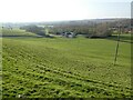
4
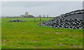
Silage Clamp
In the middle of a field just off the Sherborne to Thornford road with the large house at Lake Farm (in the next grid square) in the distance
Image: © Nigel Mykura
Taken: 29 Apr 2008
0.13 miles