IMAGES TAKEN NEAR TO
Thornford Road, SHERBORNE, DT9 6PS
Introduction
This page details the photographs taken nearby to Thornford Road, DT9 6PS by members of the Geograph project.
The Geograph project started in 2005 with the aim of publishing, organising and preserving representative images for every square kilometre of Great Britain, Ireland and the Isle of Man.

There are currently over 7.5m images from over14,400 individuals and you can help contribute to the project by visiting https://www.geograph.org.uk
Image Map (Loading...)


Getting Data...Please wait
Leaflet Map data © OpenStreetMap
Images are licensed for reuse under creativecommons.org/licenses/by-sa/2.0
Notes
- Clicking on the map will re-center to the selected point.
- The higher the marker number, the further away the image location is from the centre of the postcode.
Image Listing (19 Images Found)
Images are licensed for reuse under creativecommons.org/licenses/by-sa/2.0
Image
Details
Distance
1
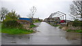
Limekiln Farm
A large farm to the south of Sherborne just off the A352 Sherborne to Dorchester road.
Image: © Nigel Mykura
Taken: 29 Apr 2008
0.03 miles
3
Old Milepost by the A352, Dancing Hill, south of Sherborne
Cast iron post by the A352, in parish of CASTLETON (WEST DORSET District), Sherborne, South of junction with B3145, by the road, on South side of road. Dorset 5 (casting), erected by the Sherborne turnpike trust in the 19th century.
Inscription reads:-
SHERBORNE
1
Milestone Society National ID: DO_SBDO01.
Image: © Colin Payne
Taken: 5 Feb 2003
0.11 miles

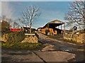
5
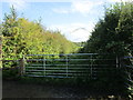
Watery Lane
A public footpath, part of the MacMillan Way.
Image: © Jonathan Thacker
Taken: 14 Sep 2017
0.12 miles
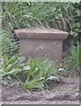
6
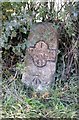
Old Milestone by Pound Road, south of Sherborne
Metal plate attached to stone post by the UC road, in parish of CASTLETON (WEST DORSET District), South of Sherborne, 200M South West of Limekiln Farm, by the road, on North side of road. Dorset 4 (iron plated), erected by the Sherborne turnpike trust in the 19th century.
Inscription reads:-
1
SHERBORNE
YETMINSTER
4½
Carved benchmark bottom of centre face.
Milestone Society National ID: DO_SBYT01.
Image: © J Tybjerg
Taken: 9 Oct 2002
0.14 miles
7

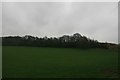
Near Limekiln Farm
A completely rural scene less than a mile from the centre of Sherborne.
Image: © Graham Horn
Taken: 6 May 2007
0.14 miles
8
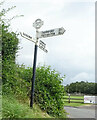
Direction Sign ? Signpost on the A352 in Castleton parish
Located at Dancing Hill on the north side of the junction of the A352 Sherborne Hill and Pound Road in Castleton parish. 3 arms and annulus & bar finial.
Milestone Society National ID: DO_ST6315
Image: © Mr Red
Taken: 1 Aug 2021
0.15 miles
9
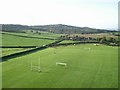
Playing Fields at Dancing Hill - Sherborne
This picture taken looking west from a recently launched hot air balloon
Image: © John Allan
Taken: Unknown
0.16 miles