IMAGES TAKEN NEAR TO
Yetminster, SHERBORNE, DT9 6JW
Introduction
This page details the photographs taken nearby to DT9 6JW by members of the Geograph project.
The Geograph project started in 2005 with the aim of publishing, organising and preserving representative images for every square kilometre of Great Britain, Ireland and the Isle of Man.

There are currently over 7.5m images from over14,400 individuals and you can help contribute to the project by visiting https://www.geograph.org.uk
Image Map
Images are licensed for reuse under creativecommons.org/licenses/by-sa/2.0
Notes
- Clicking on the map will re-center to the selected point.
- The higher the marker number, the further away the image location is from the centre of the postcode.
Image Listing (3 Images Found)
Images are licensed for reuse under creativecommons.org/licenses/by-sa/2.0
Image
Details
Distance
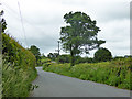
2
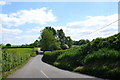
Yetminster, road to Chetnole
This road runs south from the village through the hamlet of Hamlet to Chetnole
Image: © Nigel Mykura
Taken: 18 May 2008
0.20 miles
3
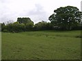
North-west of Horse Hill Farm
In the extreme north-west of the square, the footpath forming part of the Macmillan Way just clips the square. This view looking south-east shows typical grazing land.
Image: © Graham Horn
Taken: 6 May 2007
0.21 miles