IMAGES TAKEN NEAR TO
Stockbridge, SHERBORNE, DT9 6JH
Introduction
This page details the photographs taken nearby to DT9 6JH by members of the Geograph project.
The Geograph project started in 2005 with the aim of publishing, organising and preserving representative images for every square kilometre of Great Britain, Ireland and the Isle of Man.

There are currently over 7.5m images from over14,400 individuals and you can help contribute to the project by visiting https://www.geograph.org.uk
Image Map
Images are licensed for reuse under creativecommons.org/licenses/by-sa/2.0
Notes
- Clicking on the map will re-center to the selected point.
- The higher the marker number, the further away the image location is from the centre of the postcode.
Image Listing (6 Images Found)
Images are licensed for reuse under creativecommons.org/licenses/by-sa/2.0
Image
Details
Distance
1
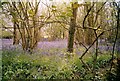
Bluebells in The Holm Bushes, Bailey Ridge, near Leigh
Image: © Peter Beaven
Taken: Unknown
0.11 miles
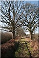
3
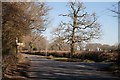
The Holm Bushes
The Holm Bushes are the woods that run along the Longburton to Leigh road in this square. The lane on the right goes to Drove Farm.
Image: © Nigel Mykura
Taken: 6 Mar 2009
0.18 miles
4
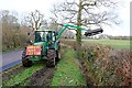
Hedge Cutting at The Holm Bushes.
This farmer was trimming hedges on the Longburton to Leigh road close to the junction with the road to Holnest on the A352
Image: © Nigel Mykura
Taken: 6 Mar 2009
0.24 miles
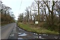
6
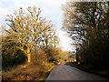
The Holm Bushes, Bailey Ridge
The road at the top of Bailey Ridge passes through The Holm Bushes woodland on its way to the A352 Sherborne-Dorchester main road. The signpost points towards Holnest. The sunlight has picked out the rather isolated looking postbox but there are a number of houses set back along the righthand side.
Image: © Sarah Smith
Taken: 8 Jan 2009
0.25 miles