IMAGES TAKEN NEAR TO
Seven Ash Common, SHERBORNE, DT9 6ET
Introduction
This page details the photographs taken nearby to DT9 6ET by members of the Geograph project.
The Geograph project started in 2005 with the aim of publishing, organising and preserving representative images for every square kilometre of Great Britain, Ireland and the Isle of Man.

There are currently over 7.5m images from over14,400 individuals and you can help contribute to the project by visiting https://www.geograph.org.uk
Image Map
Images are licensed for reuse under creativecommons.org/licenses/by-sa/2.0
Notes
- Clicking on the map will re-center to the selected point.
- The higher the marker number, the further away the image location is from the centre of the postcode.
Image Listing (2 Images Found)
Images are licensed for reuse under creativecommons.org/licenses/by-sa/2.0
Image
Details
Distance
2
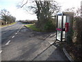
Holnest: postbox № DT9 92 and phone box
The postbox is emptied finally at 12:30 on weekdays and at 9am on Saturdays. Just beyond, the turning to the right is Seven Oaks Common Road.
Image: © Chris Downer
Taken: 24 Jan 2009
0.21 miles