IMAGES TAKEN NEAR TO
London Road, SHERBORNE, DT9 5RA
Introduction
This page details the photographs taken nearby to London Road, DT9 5RA by members of the Geograph project.
The Geograph project started in 2005 with the aim of publishing, organising and preserving representative images for every square kilometre of Great Britain, Ireland and the Isle of Man.

There are currently over 7.5m images from over14,400 individuals and you can help contribute to the project by visiting https://www.geograph.org.uk
Image Map (Loading...)


Getting Data...Please wait
Leaflet Map data © OpenStreetMap
Images are licensed for reuse under creativecommons.org/licenses/by-sa/2.0
Notes
- Clicking on the map will re-center to the selected point.
- The higher the marker number, the further away the image location is from the centre of the postcode.
Image Listing (3 Images Found)
Images are licensed for reuse under creativecommons.org/licenses/by-sa/2.0
Image
Details
Distance
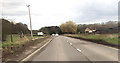
2
Crendle Hill Wood
The view north of the A30 east of Milborne Port.
Image: © Jonathan Billinger
Taken: 5 Jun 2007
0.09 miles
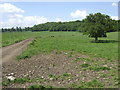
3
Former Parkland
These fields were once the parkland that surrounded Ven House. They are now separated from the house by the busy A30. The woods on the right are Crendle Hill Woods.
Image: © Nigel Mykura
Taken: 20 Feb 2012
0.18 miles