IMAGES TAKEN NEAR TO
Longburton, SHERBORNE, DT9 5NU
Introduction
This page details the photographs taken nearby to DT9 5NU by members of the Geograph project.
The Geograph project started in 2005 with the aim of publishing, organising and preserving representative images for every square kilometre of Great Britain, Ireland and the Isle of Man.

There are currently over 7.5m images from over14,400 individuals and you can help contribute to the project by visiting https://www.geograph.org.uk
Image Map
Images are licensed for reuse under creativecommons.org/licenses/by-sa/2.0
Notes
- Clicking on the map will re-center to the selected point.
- The higher the marker number, the further away the image location is from the centre of the postcode.
Image Listing (3 Images Found)
Images are licensed for reuse under creativecommons.org/licenses/by-sa/2.0
Image
Details
Distance
1
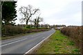
The A352 near Longburton
The A352 runs from Sherborne to Dorchester. This is the view north just north of Longburton
Image: © Nigel Mykura
Taken: 26 Feb 2009
0.01 miles
2
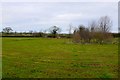
Farmland near Longburton
View north east across the northern edge of the square which is in the Blackmore Vale south of Sherborne
Image: © Nigel Mykura
Taken: 26 Feb 2009
0.14 miles
3
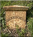
Old Milepost by the A352, north of Longburton
Cast iron post by the A352, in parish of LONGBURTON (WEST DORSET District), South of A3030 junction, set into bank by hedge and large trees, on West side of road. Dorset 5 (casting), erected by the Sherborne turnpike trust in the 19th century.
Inscription reads:-
SHERBORNE
2
Milestone Society National ID: DO_SBDO02.
Image: © Colin Payne
Taken: 5 Feb 2003
0.19 miles