IMAGES TAKEN NEAR TO
The Beeches, SHERBORNE, DT9 5NL
Introduction
This page details the photographs taken nearby to The Beeches, DT9 5NL by members of the Geograph project.
The Geograph project started in 2005 with the aim of publishing, organising and preserving representative images for every square kilometre of Great Britain, Ireland and the Isle of Man.

There are currently over 7.5m images from over14,400 individuals and you can help contribute to the project by visiting https://www.geograph.org.uk
Image Map
Images are licensed for reuse under creativecommons.org/licenses/by-sa/2.0
Notes
- Clicking on the map will re-center to the selected point.
- The higher the marker number, the further away the image location is from the centre of the postcode.
Image Listing (27 Images Found)
Images are licensed for reuse under creativecommons.org/licenses/by-sa/2.0
Image
Details
Distance
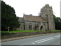
1
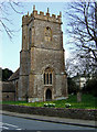
Bishop?s Caundle: parish church of Ss. Peter & Paul
With its 15th century tower.
Looking closely at Image one can see that the road has since been re-marked with double lines down its centre.
Image: © Chris Downer
Taken: Unknown
0.02 miles
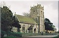
2
Church of St Peter and St Paul, Bishop's Caundle
The church of St. Peter and St. Paul has a 15th century tower and a nave of the same date which was partially rebuilt in 1864. The chancel is a good example of high Victorian taste.
Image: © Maigheach-gheal
Taken: 12 Sep 2010
0.03 miles
3
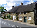
Cottages, Bishop's Caundle
There is a mixture of roofing types on the cottages that stand beside the A3030.
Image: © Maigheach-gheal
Taken: 12 Sep 2010
0.03 miles
4
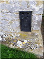
Flush Bracket S9605, Bishop's Caundle
The flush bracket is to be found on the north west wall of the Church of Sts Peter and Paul. For a view of the church http://www.geograph.org.uk/photo/2063565 and for further information on the flush bracket http://www.bench-marks.org.uk/bm19049
A bench mark is an Ordnance Survey arrowhead sign found on walls, bridges, churches and specially erected triangulation pillars where the altitude above sea-level has been accurately measured by surveyors. The arrowhead points to a horizontal line above it which marks the exact altitude.
With rivets and pivots there is no datum (horizontal line) cut, the pointed-to horizontal surface defining the datum height.
Image: © Maigheach-gheal
Taken: 12 Sep 2010
0.04 miles
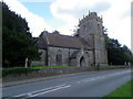
7
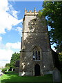
Church tower, The Church of Sts Peter and Paul
The tower dates from the 15th century.
Image: © Maigheach-gheal
Taken: 12 Sep 2010
0.04 miles
8
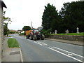
Tractor on the A3030 passing through Bishops Caundle
Image: © Basher Eyre
Taken: 6 Sep 2012
0.04 miles
9
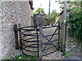
Kissing gate, Bishop's Caundle
The kissing gate gives walkers access to the footpath from the A3030.
A kissing gate is a traditional gate hung in a U or V shape that allows one person to pass at a time. In order for one person to pass fully through the gate they have to close it on the next person. Legend has it that at this point, when the two are on either side of the gate, the person in front ‘refuses’ entry to the second person until presented with a kiss.
Image: © Maigheach-gheal
Taken: 12 Sep 2010
0.04 miles