IMAGES TAKEN NEAR TO
Alweston, SHERBORNE, DT9 5JA
Introduction
This page details the photographs taken nearby to DT9 5JA by members of the Geograph project.
The Geograph project started in 2005 with the aim of publishing, organising and preserving representative images for every square kilometre of Great Britain, Ireland and the Isle of Man.

There are currently over 7.5m images from over14,400 individuals and you can help contribute to the project by visiting https://www.geograph.org.uk
Image Map (Loading...)


Getting Data...Please wait
Leaflet Map data © OpenStreetMap
Images are licensed for reuse under creativecommons.org/licenses/by-sa/2.0
Notes
- Clicking on the map will re-center to the selected point.
- The higher the marker number, the further away the image location is from the centre of the postcode.
Image Listing (2 Images Found)
Images are licensed for reuse under creativecommons.org/licenses/by-sa/2.0
Image
Details
Distance
1
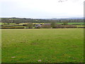
Ashcombe Farm
View across the fields above the farm from Ashcombe Lane. The fields on the slopes are nearly all pasture for stock rearing and sheep.
Image: © Nigel Mykura
Taken: 20 Feb 2012
0.01 miles
2
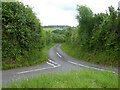
Ashcombe Lane
Looking from the end of the lane to Ashcombe Farm.
Image: © Robin Webster
Taken: 4 Jun 2017
0.15 miles