IMAGES TAKEN NEAR TO
Station Road, SHERBORNE, DT9 5EF
Introduction
This page details the photographs taken nearby to Station Road, DT9 5EF by members of the Geograph project.
The Geograph project started in 2005 with the aim of publishing, organising and preserving representative images for every square kilometre of Great Britain, Ireland and the Isle of Man.

There are currently over 7.5m images from over14,400 individuals and you can help contribute to the project by visiting https://www.geograph.org.uk
Image Map
Images are licensed for reuse under creativecommons.org/licenses/by-sa/2.0
Notes
- Clicking on the map will re-center to the selected point.
- The higher the marker number, the further away the image location is from the centre of the postcode.
Image Listing (3 Images Found)
Images are licensed for reuse under creativecommons.org/licenses/by-sa/2.0
Image
Details
Distance
1
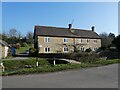
Milborne Port: Lower Kingsbury
The stream from Milborne Wick has almost disappeared under the vegetation - compare with Mike Searle's shot taken in 2007 - see Image]
Image: © Martin Bodman
Taken: 28 Jul 2012
0.22 miles
2
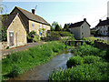
Lower Kingsbury from the bridge
Lower Kingsbury forms a part of Kingsbury Regis, to the north of Milborne Port.
Image: © Mike Searle
Taken: 1 May 2007
0.23 miles