IMAGES TAKEN NEAR TO
Blackford Way, SHERBORNE, DT9 4ND
Introduction
This page details the photographs taken nearby to Blackford Way, DT9 4ND by members of the Geograph project.
The Geograph project started in 2005 with the aim of publishing, organising and preserving representative images for every square kilometre of Great Britain, Ireland and the Isle of Man.

There are currently over 7.5m images from over14,400 individuals and you can help contribute to the project by visiting https://www.geograph.org.uk
Image Map
Images are licensed for reuse under creativecommons.org/licenses/by-sa/2.0
Notes
- Clicking on the map will re-center to the selected point.
- The higher the marker number, the further away the image location is from the centre of the postcode.
Image Listing (9 Images Found)
Images are licensed for reuse under creativecommons.org/licenses/by-sa/2.0
Image
Details
Distance
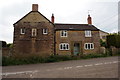
1
Homage to St Patrick's Day at North End
At old water pump house.
Image: © Roger Cornfoot
Taken: 22 Mar 2021
0.05 miles
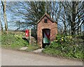
3
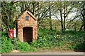
Charlton Horethorne: Water Supply feature and Post Box
This small building bears an inscription plate which says: This work was carried out by the Parish Council with voluntary subscriptions 1898.
Image: © Mr Eugene Birchall
Taken: 20 Apr 2010
0.06 miles