IMAGES TAKEN NEAR TO
Mulberry Gardens, SHERBORNE, DT9 4BY
Introduction
This page details the photographs taken nearby to Mulberry Gardens, DT9 4BY by members of the Geograph project.
The Geograph project started in 2005 with the aim of publishing, organising and preserving representative images for every square kilometre of Great Britain, Ireland and the Isle of Man.

There are currently over 7.5m images from over14,400 individuals and you can help contribute to the project by visiting https://www.geograph.org.uk
Image Map
Images are licensed for reuse under creativecommons.org/licenses/by-sa/2.0
Notes
- Clicking on the map will re-center to the selected point.
- The higher the marker number, the further away the image location is from the centre of the postcode.
Image Listing (70 Images Found)
Images are licensed for reuse under creativecommons.org/licenses/by-sa/2.0
Image
Details
Distance
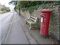
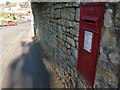
1
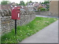
Sherborne: postbox № DT9 72, Blackberry Lane
An Elizabeth II-reign postbox mounted on a metal pole and emptied finally at 5:15pm on weekdays and at 12:30pm on Saturdays.
Image: © Chris Downer
Taken: 25 May 2013
0.03 miles

3
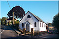
The Amateur Players of Sherborne
This old chapel is HQ for Sherborne's Dramatic Society which has been staging plays since 1934 http://www.aps-sherborne.co.uk/
Image: © Des Blenkinsopp
Taken: 28 Aug 2012
0.08 miles
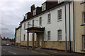
4
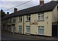
The Crown, Sherborne
Recently closed and up for sale, for the third time in 3 years.
Image: © Robert Eva
Taken: 8 Oct 2018
0.15 miles
5
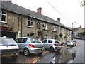
The Crown Inn, Sherborne
After heavy rain!
Image: © Roger Cornfoot
Taken: 3 Nov 2009
0.15 miles
6
Sherborne: postbox № DT9 29, Bristol Road
An Elizabeth II-reign box with a bench for company, on the B3145 as it heads northward out of town.
Image: © Chris Downer
Taken: 27 Mar 2014
0.16 miles
7
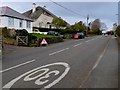
Marston Rd Sherborne
These temporary traffic lights are on the road out of Sherborne to Marston Magna close to the start of the 30 m.p.h. limit.
Image: © Nigel Mykura
Taken: 29 Mar 2011
0.17 miles
9
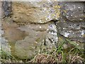
Benchmark, #73 Bristol Road, Sherborne
Ordnance Survey benchmark, described on database at http://www.bench-marks.org.uk/bm64355. See also Image
Image: © Becky Williamson
Taken: 20 Feb 2015
0.18 miles
10
Sherborne: postbox № DT9 20, Cornhill
This Victorian postbox is set into wall about halfway along Cornhill, a short stub of a road forming the eastern side of a triangle where Acreman Street meets the A30, which can be seen in the background.
The box is emptied finally at 5:15 on weekday evenings and at 12:30 on Saturday afternoons.
Image: © Chris Downer
Taken: 11 Feb 2012
0.18 miles