IMAGES TAKEN NEAR TO
Harbour Road, SHERBORNE, DT9 4AN
Introduction
This page details the photographs taken nearby to Harbour Road, DT9 4AN by members of the Geograph project.
The Geograph project started in 2005 with the aim of publishing, organising and preserving representative images for every square kilometre of Great Britain, Ireland and the Isle of Man.

There are currently over 7.5m images from over14,400 individuals and you can help contribute to the project by visiting https://www.geograph.org.uk
Image Map
Images are licensed for reuse under creativecommons.org/licenses/by-sa/2.0
Notes
- Clicking on the map will re-center to the selected point.
- The higher the marker number, the further away the image location is from the centre of the postcode.
Image Listing (20 Images Found)
Images are licensed for reuse under creativecommons.org/licenses/by-sa/2.0
Image
Details
Distance
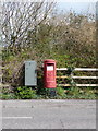
1
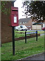
Sherborne: postbox № DT9 99, Harbour Road
This small postbox roughly faces the location of the former Coldharbour Post Office, though there is no sign now of any shop-like buildings. The box is emptied finally at 5:30pm on weekdays and at 12:45pm on Saturdays.
Image: © Chris Downer
Taken: 25 May 2013
0.08 miles
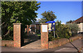
2
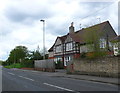
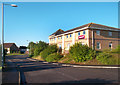
Semi-Detached Houses on Cold Harbour
The name Cold Harbour come from the french word Herberge meaning a lodging place. These were unheated resting places for travellers many hundreds of years ago. These two mock half timbered houses are probably of 1920's origin and are located on the A30 the main east west route through Sherborne. Since the building of the A303 a few miles to the north, the A 30 is no longer a long distance route from London to the west country.
Image: © Nigel Mykura
Taken: 16 May 2012
0.11 miles
3
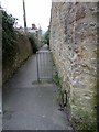
Lane off Cold Harbour with benchmark, Sherborne
Ordnance Survey benchmark, described on database at https://www.bench-marks.org.uk/bm64429. See also
Image: © Becky Williamson
Taken: 12 Feb 2015
0.11 miles
4
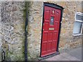
Benchmark, No 6 or 101 Coldharbour, Sherborne (Endcote)
This house is clearly marked as being No. 6 on its house sign, but the Ordnance Survey benchmark database lists it as being No. 101 Coldharbour, indicating a renumbering of the street at some time. For a full description of the benchmark, see http://www.bench-marks.org.uk/bm64429.
Image: © Becky Williamson
Taken: 22 Feb 2015
0.12 miles
7
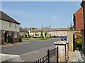
New Housing in Sherborne
This is but a small part of a large upmarket housing development on the northeast fringes of Sherborne.
Image: © Mike Searle
Taken: 21 Apr 2007
0.16 miles
8
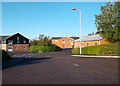
Honeywells, Cold Harbour Business Park
Image: © Des Blenkinsopp
Taken: 26 Aug 2012
0.17 miles
9
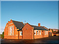
St Paul's Church
A small modern church in the unhistorical part of town.
Image: © Des Blenkinsopp
Taken: 30 Aug 2012
0.17 miles
10
Sherborne: postbox № DT9 102, Granville Way
Looking across Granville Way, a modern road on the very outskirts of town leading to an industrial estate and modern housing estate. The postbox is a 'Type K' specimen, a familiar design introduced in 1980.
Image: © Chris Downer
Taken: 27 Mar 2014
0.17 miles