IMAGES TAKEN NEAR TO
Drimpton Road, BEAMINSTER, DT8 3RS
Introduction
This page details the photographs taken nearby to Drimpton Road, DT8 3RS by members of the Geograph project.
The Geograph project started in 2005 with the aim of publishing, organising and preserving representative images for every square kilometre of Great Britain, Ireland and the Isle of Man.

There are currently over 7.5m images from over14,400 individuals and you can help contribute to the project by visiting https://www.geograph.org.uk
Image Map
Images are licensed for reuse under creativecommons.org/licenses/by-sa/2.0
Notes
- Clicking on the map will re-center to the selected point.
- The higher the marker number, the further away the image location is from the centre of the postcode.
Image Listing (9 Images Found)
Images are licensed for reuse under creativecommons.org/licenses/by-sa/2.0
Image
Details
Distance
1

Sandpit: postbox № DT8 66
A small postbox, emptied at 3:30pm on weekdays and at 9am on Saturdays.
Image: © Chris Downer
Taken: 2 Jul 2009
0.03 miles
3
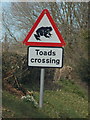
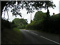
Sandpit: a warning of toads
An unusual road sign on the B3162. The sign has padlocks at each corner, so presumably it is a seasonal sign that can be removed or changed when necessary.
Image: © Chris Downer
Taken: 10 Mar 2015
0.13 miles
7
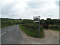
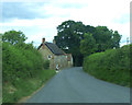
Entrance to Sandpit Mill farm on the B3162
Image: © Rob Purvis
Taken: 3 Sep 2013
0.16 miles
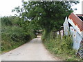
9
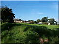
Ornamental garden at Sandpit Old Farm
These ornamental gardens consisting of a series of water ponds just to the east of the farm have been constructed on what was presumably the old pits.
Image: © Nigel Mykura
Taken: 25 Mar 2009
0.23 miles