IMAGES TAKEN NEAR TO
Broadwindsor, BEAMINSTER, DT8 3QT
Introduction
This page details the photographs taken nearby to DT8 3QT by members of the Geograph project.
The Geograph project started in 2005 with the aim of publishing, organising and preserving representative images for every square kilometre of Great Britain, Ireland and the Isle of Man.

There are currently over 7.5m images from over14,400 individuals and you can help contribute to the project by visiting https://www.geograph.org.uk
Image Map
Images are licensed for reuse under creativecommons.org/licenses/by-sa/2.0
Notes
- Clicking on the map will re-center to the selected point.
- The higher the marker number, the further away the image location is from the centre of the postcode.
Image Listing (5 Images Found)
Images are licensed for reuse under creativecommons.org/licenses/by-sa/2.0
Image
Details
Distance
1
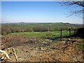
Field at Higher Park Farm
From the same spot as Image], looking to the right, with the valley of a tributary of the Axe in the background.
Image: © Derek Harper
Taken: 22 Apr 2015
0.11 miles
2
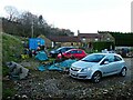
Bungalow near Broadwindsor, Dorset
Kingswood park is a modern bungalow just off the road between Broadwindsor and Mosterton 1km NNE of Broadwindsor
Image: © Nigel Mykura
Taken: 15 Jan 2008
0.18 miles
3
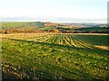
Stubble field above Higher Park Farm
Image: © Roger Cornfoot
Taken: 24 Dec 2020
0.20 miles
4
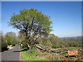
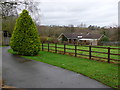
B3164 at Higher Park Farm
The road approaching Colcombe. It's mapped in dashed brown and white, indicating it's narrow with passing places.
Image: © Derek Harper
Taken: 22 Apr 2015
0.21 miles