IMAGES TAKEN NEAR TO
Kings Court, BEAMINSTER, DT8 3QA
Introduction
This page details the photographs taken nearby to Kings Court, DT8 3QA by members of the Geograph project.
The Geograph project started in 2005 with the aim of publishing, organising and preserving representative images for every square kilometre of Great Britain, Ireland and the Isle of Man.

There are currently over 7.5m images from over14,400 individuals and you can help contribute to the project by visiting https://www.geograph.org.uk
Image Map
Images are licensed for reuse under creativecommons.org/licenses/by-sa/2.0
Notes
- Clicking on the map will re-center to the selected point.
- The higher the marker number, the further away the image location is from the centre of the postcode.
Image Listing (111 Images Found)
Images are licensed for reuse under creativecommons.org/licenses/by-sa/2.0
Image
Details
Distance
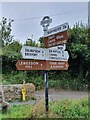
1
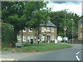
Broadwindsor, road junction B3162, B3163
Image: © Chris Gunns
Taken: 5 Jun 2019
0.03 miles
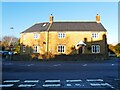
2
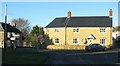
Yellow stone house by the road junction in Broadwindsor
Image: © Sarah Charlesworth
Taken: 15 Nov 2010
0.03 miles
3
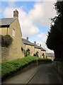
Back Lane, Broadwindsor
The B3162 drops into the centre of the village.
Image: © Derek Harper
Taken: 13 Apr 2014
0.04 miles
5
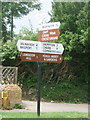
Direction Sign ? Signpost opposite Crosskeys House, Broadwindsor
Located diagonally opposite Crosskeys House, on the southwest side of the junction of the B3162 and B3163 in Broadwindsor parish. 8 arms and annulus & bar finial. See also https://www.flickr.com/photos/13706945@N00/8754826669 , https://www.geograph.org.uk/photo/1784566 and https://www.geograph.org.uk/photo/1383085.
Milestone Society National ID: DO_ST4302
Image: © C Payne
Taken: 26 Sep 2021
0.05 miles
6
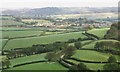
Broadwindsor: view from Pilsdon Pen
The sun catches the tower of St. John the Baptist's church, Broadwindsor, while the surroundings are under cover of cloud.
Image: © Chris Downer
Taken: Unknown
0.05 miles
7
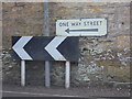
Broadwindsor: ancient and modern road signs
A modern chevron sign guides motorists around the one-way system through Broadwindsor village centre. Above it, a rarer survival is the pre-Worboys sign performing the same function. This dates from before 1961, when the Worboys report would lead to the familiar signage which is used today.
Image: © Chris Downer
Taken: 10 Mar 2015
0.05 miles
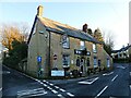
9
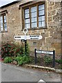
Broadwindsor: Cross Keys signpost
The fingers on this post are modern, but the original finial survives, giving the location 'Cross Keys' and the six-figure grid reference.
There is a building opposite called Cross Keys, presumably once a pub.
For a close-up of the finial, see Image
Image: © Chris Downer
Taken: 2 Jul 2009
0.05 miles
10
Direction Sign ? Signpost on High Street, Broadwindsor
Located against the wall of the Old Schoolhouse, on the east side of the B3164 High Street in Broadwindsor parish. 2 arms and annulus finial.
Milestone Society National ID: DO_ST4302C
Image: © C Payne
Taken: 26 Sep 2021
0.05 miles